Jaunpur geodata
Jaunpur (Uttar Pradesh) is a populated place; located in India in Asia/Kolkata (GMT+5.5) time zone. With population of 169,572 people, there are 256 cities with bigger population in this country. Compared to other cities in India, 68.8% of cities are located further ↓South; 78.5% of cities are located further ←West and 71.8% of cities have higher elevation than Jaunpur. Note1


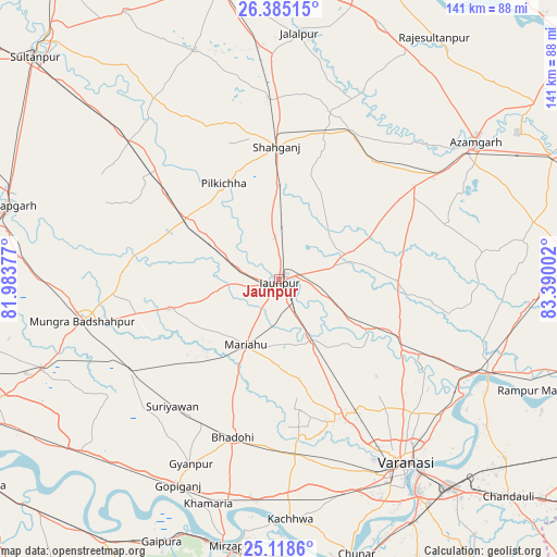
Jaunpur GPS coordinates[2]
25° 45' 12.816" North, 82° 41' 12.804" East
| Map corner | latitude | longitude |
|---|---|---|
| Upper-left | 26.38515°, | 81.98377° |
| Center: | 25.75356°, | 82.68689° |
| Lower-right: | 25.1186°, | 83.39002° |
| Map W x H: | 140.8×140.8 km | = 87.5×87.5mi |
| max Lat: | 34.9274° ⇑31.2% North |
| Jaunpur: | 25.75356° |
| min Lat: | ⇓68.8% South 8.09008° |
| min Long | Jaunpur | max Long |
| 68.82655° | 82.68689° | 96.81° |
| W 78.5%⇐ | ⇒21.5% E |
Elevation
Elevation of Jaunpur is 85 m = 279 ft, and this is 210.6 m = 691 ft below average elevation for this country.
| Max E: |
3681 m = 12077 ft | 71.8% |
| Avg. | 295.6 m = 970 ft | |
| Jaunpur | 85 m = 279 ft | |
Min E: |
1 m = 3 ft | 28.2% |
See also: Jaunpur elevation on elevation.city.
Geographical zone
Jaunpur is located in North temperate zone (between Tropic of Cancer and the Arctic Circle). Distance of this Northern Tropic circle is 257.6 km =160.1 mi to South.| Distance of | km | miles | from Jaunpur |
|---|---|---|---|
| North Pole | 7143.5 | 4438.8 | to North |
| Arctic Circle | 4537.6 | 2819.5 | to North |
| Tropic Cancer | 257.6 | 160.1 | to South |
| Equator | 2863.5 | 1779.3 | to South |


Nearby cities:
15 places around Jaunpur: (largest is in red/bold)
• Barāgaon
38.3 km =23.8 mi,  160°
160°
• Bhadohi
41.5 km =25.8 mi,  196°
196°
• Gyānpur
51.8 km =32.2 mi,  205°
205°
• Kirākat
26.3 km =16.3 mi,  119°
119°
• Kādīpur
55.9 km =34.7 mi,  325°
325°
• Machhlīshahr
28.6 km =17.8 mi,  254°
254°
• Mariāhu
18.6 km =11.6 mi, 206°
• Mehnagar
45.2 km =28.1 mi,  72°
72°
• Nizāmābād
49.8 km =30.9 mi,  48°
48°
• Patti
52.1 km =32.4 mi,  290°
290°
• Phūlpur
40.7 km =25.3 mi,  27°
27°
• Sarāi Mīr
38.2 km =23.7 mi,  37°
37°
• Shāhganj
32.9 km =20.4 mi,  359°
359°
• Suriānwān
41.9 km =26 mi,  219°
219°
• Zafarābād
7.7 km =4.8 mi,  142°
142°
Sources, notices
• [Note1] Compared only with cities in India existing in our database
• [Src1] Map data: © OpenStreetMap contributors (CC-BY-SA)
• [Src2] Other city data from geonames.org with taken over terms of usage.
• [Src3] Geographical zone / Annual Mean Temperature by Robert A. Rohde @ Wikipedia
