Mariāhu geodata
Mariāhu (Uttar Pradesh) is a populated place; located in India in Asia/Kolkata (GMT+5.5) time zone. With population of 22,248 people, there are 1888 cities with bigger population in this country. Compared to other cities in India, 67.7% of cities are located further ↓South; 78.3% of cities are located further ←West and 69.7% of cities have higher elevation than Mariāhu. Note1


Mariāhu GPS coordinates[2]
25° 36' 14.544" North, 82° 36' 13.644" East
| Map corner | latitude | longitude |
|---|---|---|
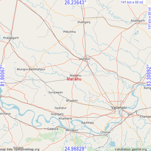
| Upper-left | 26.23643°, | 81.90067° |
| Center: | 25.60404°, | 82.60379° |
| Lower-right: | 24.96829°, | 83.30692° |
| Map W x H: | 141×141 km | = 87.6×87.6mi |
| max Lat: | 34.9274° ⇑32.3% North |
| Mariāhu: | 25.60404° |
| min Lat: | ⇓67.7% South 8.09008° |
| min Long | Mariāhu | max Long |
| 68.82655° | 82.60379° | 96.81° |
| W 78.3%⇐ | ⇒21.7% E |
Elevation
Elevation of Mariāhu is 94 m = 308 ft, and this is 201.6 m = 661 ft below average elevation for this country.
| Max E: |
3681 m = 12077 ft | 69.7% |
| Avg. | 295.6 m = 970 ft | |
| Mariāhu | 94 m = 308 ft | |
Min E: |
1 m = 3 ft | 30.3% |
See also: India elevation on elevation.city.
Geographical zone
Mariāhu is located in North temperate zone (between Tropic of Cancer and the Arctic Circle). Distance of this Northern Tropic circle is 241 km =149.8 mi to South.| Distance of | km | miles | from Mariāhu |
|---|---|---|---|
| North Pole | 7160.2 | 4449.1 | to North |
| Arctic Circle | 4554.3 | 2829.9 | to North |
| Tropic Cancer | 241 | 149.8 | to South |
| Equator | 2846.9 | 1769 | to South |


Nearby cities:
15 places around Mariāhu: (largest is in red/bold)
• Barāgaon
28.9 km =18 mi,  132°
132°
• Bhadohi
23.5 km =14.6 mi,  188°
188°
• Gyānpur
33.2 km =20.6 mi,  204°
204°
• Handiā
49.7 km =30.9 mi,  237°
237°
• Jaunpur
18.6 km =11.6 mi,  26°
26°
• Kachhwa
45.6 km =28.3 mi,  165°
165°
• Kirākat
31.5 km =19.6 mi,  83°
83°
• Machhlīshahr
21.3 km =13.2 mi,  295°
295°
• Mirzāpur
51.2 km =31.8 mi,  184°
184°
• Patti
53.6 km =33.3 mi,  311°
311°
• Phulpur
51.9 km =32.2 mi,  263°
263°
• Shāhganj
50.2 km =31.2 mi,  9°
9°
• Suriānwān
24.2 km =15 mi,  229°
229°
• Varanasi
51.8 km =32.2 mi, 128°
• Zafarābād
16.7 km =10.4 mi,  51°
51°
Sources, notices
• [Note1] Compared only with cities in India existing in our database
• [Src1] Map data: © OpenStreetMap contributors (CC-BY-SA)
• [Src2] Other city data from geonames.org with taken over terms of usage.
• [Src3] Geographical zone / Annual Mean Temperature by Robert A. Rohde @ Wikipedia
