Shāhābād geodata
Shāhābād (Haryana) is a populated place; located in India in Asia/Kolkata (GMT+5.5) time zone. With population of 39,323 people, there are 1122 cities with bigger population in this country. Compared to other cities in India, 93.3% of cities are located further ↓South; 64.6% of cities are located further →East and 62.5% of cities have lower elevation than Shāhābād. Note1


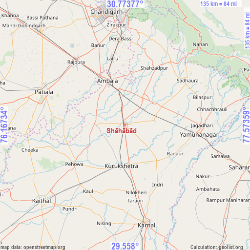
Shāhābād GPS coordinates[2]
30° 10' 3.936" North, 76° 52' 13.656" East
| Map corner | latitude | longitude |
|---|---|---|
| Upper-left | 30.77377°, | 76.16734° |
| Center: | 30.16776°, | 76.87046° |
| Lower-right: | 29.558°, | 77.57359° |
| Map W x H: | 135.2×135.2 km | = 84×84mi |
| max Lat: | 34.9274° ⇑6.7% North |
| Shāhābād: | 30.16776° |
| min Lat: | ⇓93.3% South 8.09008° |
| min Long | Shāhābād | max Long |
| 68.82655° | 76.87046° | 96.81° |
| W 35.4%⇐ | ⇒64.6% E |
Elevation
Elevation of Shāhābād is 268 m = 879 ft, and this is 27.6 m = 91 ft below average elevation for this country.
| Max E: |
3681 m = 12077 ft | 37.5% |
| Avg. | 295.6 m = 970 ft | |
| Shāhābād | 268 m = 879 ft | |
Min E: |
1 m = 3 ft | 62.5% |
See also: India elevation on elevation.city.
Geographical zone
Shāhābād is located in North temperate zone (between Tropic of Cancer and the Arctic Circle). Distance of this Northern Tropic circle is 748.4 km =465 mi to South.| Distance of | km | miles | from Shāhābād |
|---|---|---|---|
| North Pole | 6652.7 | 4133.8 | to North |
| Arctic Circle | 4046.8 | 2514.6 | to North |
| Tropic Cancer | 748.4 | 465 | to South |
| Equator | 3354.3 | 2084.3 | to South |


Nearby cities:
15 places around Shāhābād: (largest is in red/bold)
• Ambāla
22.6 km =14 mi,  342°
342°
• Bilāspur
44.4 km =27.6 mi,  69°
69°
• Ghanaur
30.7 km =19.1 mi,  306°
306°
• Indri
36.8 km =22.9 mi,  150°
150°
• Jagādhri
41.6 km =25.8 mi,  90°
90°
• Lādwa
25.7 km =16 mi,  138°
138°
• Mustafābād
27 km =16.8 mi,  81°
81°
• Narāyangarh
42.4 km =26.3 mi,  35°
35°
• Nīlokheri
37.3 km =23.2 mi,  170°
170°
• Pehowa
34.8 km =21.6 mi,  232°
232°
• Radaur
31.3 km =19.4 mi,  120°
120°
• Rājpura
43.6 km =27.1 mi,  322°
322°
• Sanaur
42.3 km =26.3 mi,  290°
290°
• Thānesar
21.9 km =13.6 mi,  189°
189°
• Yamunānagar
40 km =24.9 mi,  96°
96°
Sources, notices
• [Note1] Compared only with cities in India existing in our database
• [Src1] Map data: © OpenStreetMap contributors (CC-BY-SA)
• [Src2] Other city data from geonames.org with taken over terms of usage.
• [Src3] Geographical zone / Annual Mean Temperature by Robert A. Rohde @ Wikipedia
