Bilāspur geodata
Bilāspur (Haryana) is a populated place; located in India in Asia/Kolkata (GMT+5.5) time zone. With population of 10,709 people, there are 2868 cities with bigger population in this country. Compared to other cities in India, 93.8% of cities are located further ↓South; 59.8% of cities are located further →East and 67.6% of cities have lower elevation than Bilāspur. Note1


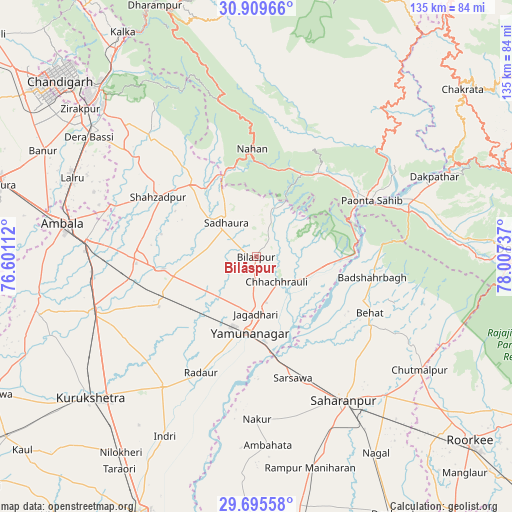
Bilāspur GPS coordinates[2]
30° 18' 16.2" North, 77° 18' 15.264" East
| Map corner | latitude | longitude |
|---|---|---|
| Upper-left | 30.90966°, | 76.60112° |
| Center: | 30.3045°, | 77.30424° |
| Lower-right: | 29.69558°, | 78.00737° |
| Map W x H: | 135×135 km | = 83.9×83.9mi |
| max Lat: | 34.9274° ⇑6.2% North |
| Bilāspur: | 30.3045° |
| min Lat: | ⇓93.8% South 8.09008° |
| min Long | Bilāspur | max Long |
| 68.82655° | 77.30424° | 96.81° |
| W 40.2%⇐ | ⇒59.8% E |
Elevation
Elevation of Bilāspur is 306 m = 1004 ft, and this is 10.4 m = 34 ft above average elevation for this country.
| Max E: |
3681 m = 12077 ft | 32.4% |
| Bilāspur | 306 m 1004 ft | |
| Avg. | 295.6 m = 970 ft | |
Min E: |
1 m = 3 ft | 67.6% |
See also: India elevation on elevation.city.
Geographical zone
Bilāspur is located in North temperate zone (between Tropic of Cancer and the Arctic Circle). Distance of this Northern Tropic circle is 763.6 km =474.5 mi to South.| Distance of | km | miles | from Bilāspur |
|---|---|---|---|
| North Pole | 6637.5 | 4124.4 | to North |
| Arctic Circle | 4031.6 | 2505.1 | to North |
| Tropic Cancer | 763.6 | 474.5 | to South |
| Equator | 3369.5 | 2093.7 | to South |


Nearby cities:
15 places around Bilāspur: (largest is in red/bold)
• Behat
33.2 km =20.6 mi,  116°
116°
• Būriya
17 km =10.6 mi,  162°
162°
• Chhachhrauli
8.5 km =5.3 mi,  140°
140°
• Harbatpur
44.4 km =27.6 mi,  70°
70°
• Jagādhri
15.3 km =9.5 mi,  180°
180°
• Lādwa
42.6 km =26.5 mi,  215°
215°
• Mustafābād
18.8 km =11.7 mi,  232°
232°
• Nakūr
42.8 km =26.6 mi, 179°
• Narāyangarh
25.6 km =15.9 mi,  318°
318°
• Nāhan
28.5 km =17.7 mi,  358°
358°
• Pāonta Sāhib
34.1 km =21.2 mi,  64°
64°
• Radaur
34.2 km =21.3 mi,  205°
205°
• Sahāranpur
44 km =27.3 mi,  148°
148°
• Shāhābād
44.4 km =27.6 mi,  249°
249°
• Yamunānagar
19.7 km =12.2 mi,  185°
185°
Sources, notices
• [Note1] Compared only with cities in India existing in our database
• [Src1] Map data: © OpenStreetMap contributors (CC-BY-SA)
• [Src2] Other city data from geonames.org with taken over terms of usage.
• [Src3] Geographical zone / Annual Mean Temperature by Robert A. Rohde @ Wikipedia
