Mustafābād geodata
Mustafābād (Haryana) is a populated place; located in India in Asia/Kolkata (GMT+5.5) time zone. With population of 8,974 people, there are 3036 cities with bigger population in this country. Compared to other cities in India, 93.4% of cities are located further ↓South; 61.5% of cities are located further →East and 64.8% of cities have lower elevation than Mustafābād. Note1


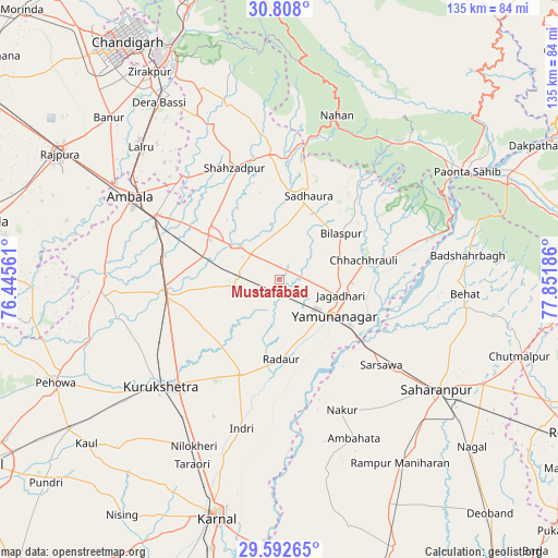
Mustafābād GPS coordinates[2]
30° 12' 7.92" North, 77° 8' 55.428" East
| Map corner | latitude | longitude |
|---|---|---|
| Upper-left | 30.808°, | 76.44561° |
| Center: | 30.2022°, | 77.14873° |
| Lower-right: | 29.59265°, | 77.85186° |
| Map W x H: | 135.1×135.1 km | = 83.9×83.9mi |
| max Lat: | 34.9274° ⇑6.6% North |
| Mustafābād: | 30.2022° |
| min Lat: | ⇓93.4% South 8.09008° |
| min Long | Mustafābād | max Long |
| 68.82655° | 77.14873° | 96.81° |
| W 38.5%⇐ | ⇒61.5% E |
Elevation
Elevation of Mustafābād is 284 m = 932 ft, and this is 11.6 m = 38 ft below average elevation for this country.
| Max E: |
3681 m = 12077 ft | 35.2% |
| Avg. | 295.6 m = 970 ft | |
| Mustafābād | 284 m = 932 ft | |
Min E: |
1 m = 3 ft | 64.8% |
See also: India elevation on elevation.city.
Geographical zone
Mustafābād is located in North temperate zone (between Tropic of Cancer and the Arctic Circle). Distance of this Northern Tropic circle is 752.3 km =467.5 mi to South.| Distance of | km | miles | from Mustafābād |
|---|---|---|---|
| North Pole | 6648.9 | 4131.4 | to North |
| Arctic Circle | 4043 | 2512.2 | to North |
| Tropic Cancer | 752.3 | 467.5 | to South |
| Equator | 3358.2 | 2086.7 | to South |


Nearby cities:
15 places around Mustafābād: (largest is in red/bold)
• Ambahta
42.4 km =26.3 mi,  154°
154°
• Ambāla
38 km =23.6 mi,  297°
297°
• Bilāspur
18.8 km =11.7 mi,  52°
52°
• Būriya
20.7 km =12.9 mi,  103°
103°
• Chhachhrauli
20.9 km =13 mi,  76°
76°
• Indri
36.8 km =22.9 mi,  193°
193°
• Jagādhri
15.4 km =9.6 mi, 104°
• Lādwa
25.2 km =15.7 mi,  203°
203°
• Nakūr
34.8 km =21.6 mi, 154°
• Narāyangarh
30.7 km =19.1 mi,  356°
356°
• Nāhan
42.2 km =26.2 mi,  19°
19°
• Radaur
19.5 km =12.1 mi,  179°
179°
• Shāhābād
27 km =16.8 mi,  261°
261°
• Thānesar
39.7 km =24.7 mi,  230°
230°
• Yamunānagar
15.4 km =9.6 mi,  122°
122°
Sources, notices
• [Note1] Compared only with cities in India existing in our database
• [Src1] Map data: © OpenStreetMap contributors (CC-BY-SA)
• [Src2] Other city data from geonames.org with taken over terms of usage.
• [Src3] Geographical zone / Annual Mean Temperature by Robert A. Rohde @ Wikipedia
