Pennāthur geodata
Pennāthur (Tamil Nadu) is a populated place; located in India in Asia/Kolkata (GMT+5.5) time zone. With population of 8,257 people, there are 3106 cities with bigger population in this country. Compared to other cities in India, 89.2% of cities are located further ↑North; 61.3% of cities are located further ←West and 59.5% of cities have higher elevation than Pennāthur. Note1


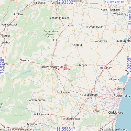
Pennāthur GPS coordinates[2]
12° 14' 48.516" North, 79° 13' 33.312" East
| Map corner | latitude | longitude |
|---|---|---|
| Upper-left | 12.93302°, | 78.5228° |
| Center: | 12.24681°, | 79.22592° |
| Lower-right: | 11.55881°, | 79.92905° |
| Map W x H: | 152.8×152.8 km | = 94.9×94.9mi |
| max Lat: | 34.9274° ⇑89.2% North |
| Pennāthur: | 12.24681° |
| min Lat: | ⇓10.8% South 8.09008° |
| min Long | Pennāthur | max Long |
| 68.82655° | 79.22592° | 96.81° |
| W 61.3%⇐ | ⇒38.7% E |
Elevation
Elevation of Pennāthur is 151 m = 495 ft, and this is 144.6 m = 474 ft below average elevation for this country.
| Max E: |
3681 m = 12077 ft | 59.5% |
| Avg. | 295.6 m = 970 ft | |
| Pennāthur | 151 m = 495 ft | |
Min E: |
1 m = 3 ft | 40.5% |
See also: India elevation on elevation.city.
Geographical zone
Pennāthur is located in North Torrid zone (between Equator and Tropic of Cancer). Distance of this Northern Tropic circle is 1244.2 km =773.1 mi to North.| Distance of | km | miles | from Pennāthur |
|---|---|---|---|
| North Pole | 8645.3 | 5371.9 | to North |
| Arctic Circle | 6039.5 | 3752.8 | to North |
| Tropic Cancer | 1244.2 | 773.1 | to North |
| Equator | 1361.7 | 846.1 | to South |


Nearby cities:
15 places around Pennāthur: (largest is in red/bold)
• Arni
47.2 km =29.3 mi,  7°
7°
• Chengam
47.7 km =29.6 mi,  278°
278°
• Desūr
34.9 km =21.7 mi,  52°
52°
• Gingee
20.8 km =12.9 mi,  88°
88°
• Manalūrpettai
30.3 km =18.8 mi,  208°
208°
• Nangilickondan
27.1 km =16.8 mi, 87°
• Peranamallūr
42.5 km =26.4 mi,  32°
32°
• Polūr
31.5 km =19.6 mi,  339°
339°
• Tindivanam
46.7 km =29 mi, 91°
• Tirukkoyilur
31.3 km =19.4 mi,  184°
184°
• Tiruvannāmalai
16.6 km =10.3 mi,  262°
262°
• Vandavāsi
50.2 km =31.2 mi,  55°
55°
• Vettavalam
15.6 km =9.7 mi,  172°
172°
• Vikravāndi
41.9 km =26 mi,  123°
123°
• Villupuram
44.8 km =27.8 mi,  139°
139°
Sources, notices
• [Note1] Compared only with cities in India existing in our database
• [Src1] Map data: © OpenStreetMap contributors (CC-BY-SA)
• [Src2] Other city data from geonames.org with taken over terms of usage.
• [Src3] Geographical zone / Annual Mean Temperature by Robert A. Rohde @ Wikipedia
