Zahirābād geodata
Zahirābād (Telangana) is a populated place; located in India in Asia/Kolkata (GMT+5.5) time zone. With population of 46,504 people, there are 950 cities with bigger population in this country. Compared to other cities in India, 72.5% of cities are located further ↑North; 56% of cities are located further →East and 89.5% of cities have lower elevation than Zahirābād. Note1


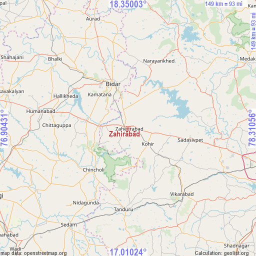
Zahirābād GPS coordinates[2]
17° 40' 52.968" North, 77° 36' 26.748" East
| Map corner | latitude | longitude |
|---|---|---|
| Upper-left | 18.35003°, | 76.90431° |
| Center: | 17.68138°, | 77.60743° |
| Lower-right: | 17.01024°, | 78.31056° |
| Map W x H: | 149×149 km | = 92.6×92.6mi |
| max Lat: | 34.9274° ⇑72.5% North |
| Zahirābād: | 17.68138° |
| min Lat: | ⇓27.5% South 8.09008° |
| min Long | Zahirābād | max Long |
| 68.82655° | 77.60743° | 96.81° |
| W 44%⇐ | ⇒56% E |
Elevation
Elevation of Zahirābād is 626 m = 2054 ft, and this is 330.4 m = 1084 ft above average elevation for this country.
| Max E: |
3681 m = 12077 ft | 10.5% |
| Zahirābād | 626 m 2054 ft | |
| Avg. | 295.6 m = 970 ft | |
Min E: |
1 m = 3 ft | 89.5% |
See also: Zahirābād elevation on elevation.city.
Geographical zone
Zahirābād is located in North Torrid zone (between Equator and Tropic of Cancer). Distance of this Northern Tropic circle is 639.9 km =397.6 mi to North.| Distance of | km | miles | from Zahirābād |
|---|---|---|---|
| North Pole | 8041.1 | 4996.5 | to North |
| Arctic Circle | 5435.2 | 3377.3 | to North |
| Tropic Cancer | 639.9 | 397.6 | to North |
| Equator | 1966 | 1221.6 | to South |


Nearby cities:
15 places around Zahirābād: (largest is in red/bold)
• Andol
51.9 km =32.2 mi,  73°
73°
• Aurād
66.8 km =41.5 mi,  342°
342°
• Bhālki
58.5 km =36.4 mi,  313°
313°
• Bīdar
27.1 km =16.8 mi, 342°
• Chandūr
56.4 km =35 mi, 67°
• Chincholi
31.3 km =19.4 mi,  219°
219°
• Homnābād
52 km =32.3 mi,  281°
281°
• Kurgunta
60.4 km =37.5 mi,  206°
206°
• Patancheru
71.6 km =44.5 mi,  103°
103°
• Sadāseopet
37.2 km =23.1 mi, 100°
• Sangāreddi
51.2 km =31.8 mi, 97°
• Seram
65.3 km =40.6 mi, 211°
• Singāpur
59.8 km =37.2 mi,  113°
113°
• Tāndūr
48.2 km =30 mi,  183°
183°
• Vikārābād
49.5 km =30.8 mi,  140°
140°
Sources, notices
• [Note1] Compared only with cities in India existing in our database
• [Src1] Map data: © OpenStreetMap contributors (CC-BY-SA)
• [Src2] Other city data from geonames.org with taken over terms of usage.
• [Src3] Geographical zone / Annual Mean Temperature by Robert A. Rohde @ Wikipedia
