Tāndūr geodata
Tāndūr (Telangana) is a populated place; located in India in Asia/Kolkata (GMT+5.5) time zone. With population of 63,239 people, there are 696 cities with bigger population in this country. Compared to other cities in India, 74.2% of cities are located further ↑North; 56.4% of cities are located further →East and 79.5% of cities have lower elevation than Tāndūr. Note1


Tāndūr GPS coordinates[2]
17° 14' 54.564" North, 77° 34' 37.128" East
| Map corner | latitude | longitude |
|---|---|---|
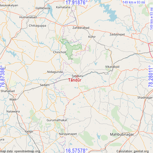
| Upper-left | 17.91876°, | 76.87386° |
| Center: | 17.24849°, | 77.57698° |
| Lower-right: | 16.57578°, | 78.28011° |
| Map W x H: | 149.3×149.3 km | = 92.8×92.8mi |
| max Lat: | 34.9274° ⇑74.2% North |
| Tāndūr: | 17.24849° |
| min Lat: | ⇓25.8% South 8.09008° |
| min Long | Tāndūr | max Long |
| 68.82655° | 77.57698° | 96.81° |
| W 43.6%⇐ | ⇒56.4% E |
Elevation
Elevation of Tāndūr is 452 m = 1483 ft, and this is 156.4 m = 513 ft above average elevation for this country.
| Max E: |
3681 m = 12077 ft | 20.5% |
| Tāndūr | 452 m 1483 ft | |
| Avg. | 295.6 m = 970 ft | |
Min E: |
1 m = 3 ft | 79.5% |
See also: Tāndūr elevation on elevation.city.
Geographical zone
Tāndūr is located in North Torrid zone (between Equator and Tropic of Cancer). Distance of this Northern Tropic circle is 688.1 km =427.6 mi to North.| Distance of | km | miles | from Tāndūr |
|---|---|---|---|
| North Pole | 8089.2 | 5026.4 | to North |
| Arctic Circle | 5483.3 | 3407.2 | to North |
| Tropic Cancer | 688.1 | 427.6 | to North |
| Equator | 1917.9 | 1191.7 | to South |


Nearby cities:
15 places around Tāndūr: (largest is in red/bold)
• Chincholi
29.4 km =18.3 mi,  325°
325°
• Chītāpur
54.3 km =33.7 mi,  255°
255°
• Farrukhnagar
69.2 km =43 mi,  105°
105°
• Gurmatkāl
46.7 km =29 mi,  205°
205°
• Kurgunta
24.1 km =15 mi, 255°
• Nārāyanpet
56.3 km =35 mi,  188°
188°
• Sadāseopet
57.3 km =35.6 mi,  44°
44°
• Sangāreddi
68.4 km =42.5 mi,  52°
52°
• Seram
31.5 km =19.6 mi, 255°
• Shāhābād
68.5 km =42.6 mi, 258°
• Singāpur
63.2 km =39.3 mi,  67°
67°
• Vikārābād
36.2 km =22.5 mi, 74°
• Wādi
66 km =41 mi,  250°
250°
• Yādgīr
70.8 km =44 mi,  221°
221°
• Zahirābād
48.2 km =30 mi,  3°
3°
Sources, notices
• [Note1] Compared only with cities in India existing in our database
• [Src1] Map data: © OpenStreetMap contributors (CC-BY-SA)
• [Src2] Other city data from geonames.org with taken over terms of usage.
• [Src3] Geographical zone / Annual Mean Temperature by Robert A. Rohde @ Wikipedia
