Farrukhnagar geodata
Farrukhnagar (Telangana) is a populated place; located in India in Asia/Kolkata (GMT+5.5) time zone. With population of 39,766 people, there are 1113 cities with bigger population in this country. Compared to other cities in India, 74.6% of cities are located further ↑North; 51.1% of cities are located further ←West and 90.7% of cities have lower elevation than Farrukhnagar. Note1


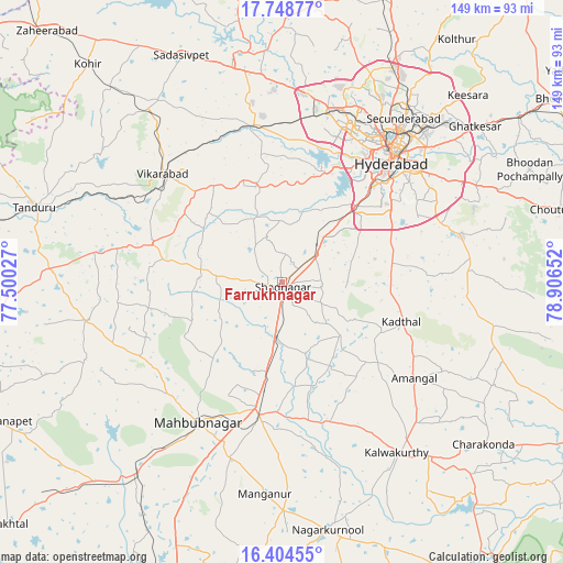
Farrukhnagar GPS coordinates[2]
17° 4' 40.332" North, 78° 12' 12.204" East
| Map corner | latitude | longitude |
|---|---|---|
| Upper-left | 17.74877°, | 77.50027° |
| Center: | 17.07787°, | 78.20339° |
| Lower-right: | 16.40455°, | 78.90652° |
| Map W x H: | 149.5×149.5 km | = 92.9×92.9mi |
| max Lat: | 34.9274° ⇑74.6% North |
| Farrukhnagar: | 17.07787° |
| min Lat: | ⇓25.4% South 8.09008° |
| min Long | Farrukhnagar | max Long |
| 68.82655° | 78.20339° | 96.81° |
| W 51.1%⇐ | ⇒48.9% E |
Elevation
Elevation of Farrukhnagar is 647 m = 2123 ft, and this is 351.4 m = 1153 ft above average elevation for this country.
| Max E: |
3681 m = 12077 ft | 9.3% |
| Farrukhnagar | 647 m 2123 ft | |
| Avg. | 295.6 m = 970 ft | |
Min E: |
1 m = 3 ft | 90.7% |
See also: India elevation on elevation.city.
Geographical zone
Farrukhnagar is located in North Torrid zone (between Equator and Tropic of Cancer). Distance of this Northern Tropic circle is 707 km =439.3 mi to North.| Distance of | km | miles | from Farrukhnagar |
|---|---|---|---|
| North Pole | 8108.2 | 5038.2 | to North |
| Arctic Circle | 5502.3 | 3419 | to North |
| Tropic Cancer | 707 | 439.3 | to North |
| Equator | 1898.9 | 1179.9 | to South |


Nearby cities:
15 places around Farrukhnagar: (largest is in red/bold)
• Bālāpur
40.7 km =25.3 mi,  50°
50°
• Gaddi Annaram
46.8 km =29.1 mi, 46°
• Hyderabad
43.4 km =27 mi,  38°
38°
• Kūkatpalli
50.5 km =31.4 mi,  26°
26°
• Lal Bahadur Nagar
48.1 km =29.9 mi, 51°
• Mahbūbnagar
43.8 km =27.2 mi,  211°
211°
• Malkajgiri
53.6 km =33.3 mi, 39°
• Patancheru
51.1 km =31.8 mi,  7°
7°
• Quthbullapur
54.3 km =33.7 mi, 29°
• Secunderabad
59.5 km =37 mi, 37°
• Serilingampalle
47.3 km =29.4 mi, 12°
• Singāpur
44.4 km =27.6 mi,  349°
349°
• Srīrāmnagar
21.7 km =13.5 mi, 14°
• Uppal Kalan
52.5 km =32.6 mi, 46°
• Vikārābād
43 km =26.7 mi,  312°
312°
Sources, notices
• [Note1] Compared only with cities in India existing in our database
• [Src1] Map data: © OpenStreetMap contributors (CC-BY-SA)
• [Src2] Other city data from geonames.org with taken over terms of usage.
• [Src3] Geographical zone / Annual Mean Temperature by Robert A. Rohde @ Wikipedia
