Ambur geodata
Ambur (Tamil Nadu) is a populated place; located in India in Asia/Kolkata (GMT+5.5) time zone. With population of 109,873 people, there are 405 cities with bigger population in this country. Compared to other cities in India, 87.4% of cities are located further ↑North; 56% of cities are located further ←West and 69.5% of cities have lower elevation than Ambur. Note1


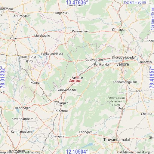
Ambur GPS coordinates[2]
12° 47' 29.868" North, 78° 42' 59.184" East
| Map corner | latitude | longitude |
|---|---|---|
| Upper-left | 13.47636°, | 78.01332° |
| Center: | 12.79163°, | 78.71644° |
| Lower-right: | 12.10504°, | 79.41957° |
| Map W x H: | 152.5×152.5 km | = 94.8×94.8mi |
| max Lat: | 34.9274° ⇑87.4% North |
| Ambur: | 12.79163° |
| min Lat: | ⇓12.6% South 8.09008° |
| min Long | Ambur | max Long |
| 68.82655° | 78.71644° | 96.81° |
| W 56%⇐ | ⇒44% E |
Elevation
Elevation of Ambur is 322 m = 1056 ft, and this is 26.4 m = 87 ft above average elevation for this country.
| Max E: |
3681 m = 12077 ft | 30.5% |
| Ambur | 322 m 1056 ft | |
| Avg. | 295.6 m = 970 ft | |
Min E: |
1 m = 3 ft | 69.5% |
See also: Ambur elevation on elevation.city.
Geographical zone
Ambur is located in North Torrid zone (between Equator and Tropic of Cancer). Distance of this Northern Tropic circle is 1183.6 km =735.5 mi to North.| Distance of | km | miles | from Ambur |
|---|---|---|---|
| North Pole | 8584.8 | 5334.3 | to North |
| Arctic Circle | 5978.9 | 3715.1 | to North |
| Tropic Cancer | 1183.6 | 735.5 | to North |
| Equator | 1422.3 | 883.8 | to South |


Nearby cities:
15 places around Ambur: (largest is in red/bold)
• Alangāyam
19.2 km =11.9 mi,  168°
168°
• Gudiyatham
24.2 km =15 mi,  44°
44°
• Jalārpet
29.1 km =18.1 mi,  212°
212°
• Kunnattūr
54.2 km =33.7 mi,  204°
204°
• Kuppam
40.9 km =25.4 mi,  263°
263°
• Kātpādi
50.5 km =31.4 mi,  66°
66°
• Odugattūr
18.3 km =11.4 mi,  98°
98°
• Pallikondai
27.6 km =17.1 mi,  62°
62°
• Palmaner
45.5 km =28.3 mi,  4°
4°
• Peranāmpattu
15.9 km =9.9 mi, 0°
• Polūr
54 km =33.6 mi,  125°
125°
• Pudūr
51.7 km =32.1 mi, 63°
• Robertsonpet
51.2 km =31.8 mi,  290°
290°
• Vaniyambadi
16.1 km =10 mi,  220°
220°
• Vellore
47.3 km =29.4 mi, 72°
Sources, notices
• [Note1] Compared only with cities in India existing in our database
• [Src1] Map data: © OpenStreetMap contributors (CC-BY-SA)
• [Src2] Other city data from geonames.org with taken over terms of usage.
• [Src3] Geographical zone / Annual Mean Temperature by Robert A. Rohde @ Wikipedia
