Polūr geodata
Polūr (Tamil Nadu) is a populated place; located in India in Asia/Kolkata (GMT+5.5) time zone. With population of 26,290 people, there are 1622 cities with bigger population in this country. Compared to other cities in India, 88.5% of cities are located further ↑North; 60.1% of cities are located further ←West and 54.8% of cities have higher elevation than Polūr. Note1


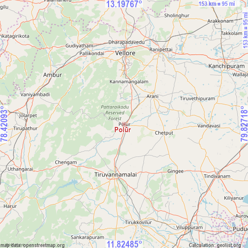
Polūr GPS coordinates[2]
12° 30' 43.812" North, 79° 7' 26.58" East
| Map corner | latitude | longitude |
|---|---|---|
| Upper-left | 13.19767°, | 78.42093° |
| Center: | 12.51217°, | 79.12405° |
| Lower-right: | 11.82485°, | 79.82718° |
| Map W x H: | 152.6×152.6 km | = 94.8×94.8mi |
| max Lat: | 34.9274° ⇑88.5% North |
| Polūr: | 12.51217° |
| min Lat: | ⇓11.5% South 8.09008° |
| min Long | Polūr | max Long |
| 68.82655° | 79.12405° | 96.81° |
| W 60.1%⇐ | ⇒39.9% E |
Elevation
Elevation of Polūr is 176 m = 577 ft, and this is 119.6 m = 392 ft below average elevation for this country.
| Max E: |
3681 m = 12077 ft | 54.8% |
| Avg. | 295.6 m = 970 ft | |
| Polūr | 176 m = 577 ft | |
Min E: |
1 m = 3 ft | 45.2% |
See also: India elevation on elevation.city.
Geographical zone
Polūr is located in North Torrid zone (between Equator and Tropic of Cancer). Distance of this Northern Tropic circle is 1214.7 km =754.8 mi to North.| Distance of | km | miles | from Polūr |
|---|---|---|---|
| North Pole | 8615.8 | 5353.6 | to North |
| Arctic Circle | 6010 | 3734.4 | to North |
| Tropic Cancer | 1214.7 | 754.8 | to North |
| Equator | 1391.2 | 864.5 | to South |


Nearby cities:
15 places around Polūr: (largest is in red/bold)
• Alangāyam
42.2 km =26.2 mi,  286°
286°
• Arni
24.6 km =15.3 mi,  45°
45°
• Chengam
42.6 km =26.5 mi,  237°
237°
• Cheyyar
48.4 km =30.1 mi,  70°
70°
• Desūr
39.7 km =24.7 mi,  102°
102°
• Gingee
43 km =26.7 mi,  132°
132°
• Kalavai
43.1 km =26.8 mi, 48°
• Nangilickondan
47.6 km =29.6 mi, 126°
• Odugattūr
38.6 km =24 mi,  317°
317°
• Pallikondai
47.9 km =29.8 mi,  335°
335°
• Pennāthur
31.5 km =19.6 mi,  159°
159°
• Peranamallūr
34.2 km =21.3 mi,  79°
79°
• Tiruvannāmalai
32.2 km =20 mi,  189°
189°
• Vellore
45.2 km =28.1 mi,  1°
1°
• Vettavalam
46.9 km =29.1 mi, 163°
Sources, notices
• [Note1] Compared only with cities in India existing in our database
• [Src1] Map data: © OpenStreetMap contributors (CC-BY-SA)
• [Src2] Other city data from geonames.org with taken over terms of usage.
• [Src3] Geographical zone / Annual Mean Temperature by Robert A. Rohde @ Wikipedia
