Thanna Mandi geodata
Thanna Mandi (Jammu and Kashmir) is a populated place; located in India in Asia/Kolkata (GMT+5.5) time zone. With population of 3,857 people, there are 3385 cities with bigger population in this country. Compared to other cities in India, 99.2% of cities are located further ↓South; 87.6% of cities are located further →East and 97.9% of cities have lower elevation than Thanna Mandi. Note1


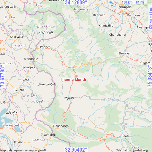
Thanna Mandi GPS coordinates[2]
33° 32' 31.344" North, 74° 22' 51.6" East
| Map corner | latitude | longitude |
|---|---|---|
| Upper-left | 34.12609°, | 73.67788° |
| Center: | 33.54204°, | 74.381° |
| Lower-right: | 32.95402°, | 75.08413° |
| Map W x H: | 130.3×130.3 km | = 81×81mi |
| max Lat: | 34.9274° ⇑0.8% North |
| Thanna Mandi: | 33.54204° |
| min Lat: | ⇓99.2% South 8.09008° |
| min Long | Thanna Mandi | max Long |
| 68.82655° | 74.381° | 96.81° |
| W 12.4%⇐ | ⇒87.6% E |
Elevation
Elevation of Thanna Mandi is 1572 m = 5157 ft, and this is 1276.4 m = 4188 ft above average elevation for this country.
| Max E: |
3681 m = 12077 ft | 2.1% |
| Thanna Mandi | 1572 m 5157 ft | |
| Avg. | 295.6 m = 970 ft | |
Min E: |
1 m = 3 ft | 97.9% |
See also: India elevation on elevation.city.
Geographical zone
Thanna Mandi is located in North temperate zone (between Tropic of Cancer and the Arctic Circle). Distance of this Northern Tropic circle is 1123.6 km =698.2 mi to South.| Distance of | km | miles | from Thanna Mandi |
|---|---|---|---|
| North Pole | 6277.5 | 3900.7 | to North |
| Arctic Circle | 3671.6 | 2281.4 | to North |
| Tropic Cancer | 1123.6 | 698.2 | to South |
| Equator | 3729.5 | 2317.4 | to South |


Nearby cities:
15 places around Thanna Mandi: (largest is in red/bold)
• Gulmarg
56.9 km =35.4 mi,  0°
0°
• Kulgam
60.2 km =37.4 mi,  79°
79°
• Kupwāra
55.4 km =34.4 mi,  348°
348°
• Māgām
64.2 km =39.9 mi,  17°
17°
• Pattan
70.7 km =43.9 mi,  13°
13°
• Pulwama
60.5 km =37.6 mi,  52°
52°
• Pūnch
36.8 km =22.9 mi,  313°
313°
• Qāzigund
71.3 km =44.3 mi, 81°
• Rajaori
19.7 km =12.2 mi,  199°
199°
• Riāsi
66.2 km =41.1 mi,  140°
140°
• Rāmgarh
21.2 km =13.2 mi,  223°
223°
• Shupīyan
46.3 km =28.8 mi,  65°
65°
• Soyībug
66.6 km =41.4 mi,  26°
26°
• Tsrār Sharīf
50.4 km =31.3 mi,  44°
44°
• Uri
67.2 km =41.8 mi,  333°
333°
Sources, notices
• [Note1] Compared only with cities in India existing in our database
• [Src1] Map data: © OpenStreetMap contributors (CC-BY-SA)
• [Src2] Other city data from geonames.org with taken over terms of usage.
• [Src3] Geographical zone / Annual Mean Temperature by Robert A. Rohde @ Wikipedia
