Peranamallūr geodata
Peranamallūr (Tamil Nadu) is a populated place; located in India in Asia/Kolkata (GMT+5.5) time zone. With population of 5,723 people, there are 3306 cities with bigger population in this country. Compared to other cities in India, 88.3% of cities are located further ↑North; 63% of cities are located further ←West and 63.4% of cities have higher elevation than Peranamallūr. Note1


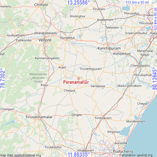
Peranamallūr GPS coordinates[2]
12° 34' 13.872" North, 79° 25' 59.952" East
| Map corner | latitude | longitude |
|---|---|---|
| Upper-left | 13.25586°, | 78.7302° |
| Center: | 12.57052°, | 79.43332° |
| Lower-right: | 11.88335°, | 80.13645° |
| Map W x H: | 152.6×152.6 km | = 94.8×94.8mi |
| max Lat: | 34.9274° ⇑88.3% North |
| Peranamallūr: | 12.57052° |
| min Lat: | ⇓11.7% South 8.09008° |
| min Long | Peranamallūr | max Long |
| 68.82655° | 79.43332° | 96.81° |
| W 63%⇐ | ⇒37% E |
Elevation
Elevation of Peranamallūr is 130 m = 427 ft, and this is 165.6 m = 543 ft below average elevation for this country.
| Max E: |
3681 m = 12077 ft | 63.4% |
| Avg. | 295.6 m = 970 ft | |
| Peranamallūr | 130 m = 427 ft | |
Min E: |
1 m = 3 ft | 36.6% |
See also: India elevation on elevation.city.
Geographical zone
Peranamallūr is located in North Torrid zone (between Equator and Tropic of Cancer). Distance of this Northern Tropic circle is 1208.2 km =750.7 mi to North.| Distance of | km | miles | from Peranamallūr |
|---|---|---|---|
| North Pole | 8609.4 | 5349.6 | to North |
| Arctic Circle | 6003.5 | 3730.4 | to North |
| Tropic Cancer | 1208.2 | 750.7 | to North |
| Equator | 1397.7 | 868.5 | to South |


Nearby cities:
15 places around Peranamallūr: (largest is in red/bold)
• Arcot
39.3 km =24.4 mi,  341°
341°
• Arni
19.4 km =12.1 mi,  303°
303°
• Cheyyar
15.6 km =9.7 mi,  49°
49°
• Desūr
15.7 km =9.8 mi,  160°
160°
• Dūsi
35.1 km =21.8 mi, 49°
• Gingee
35.4 km =22 mi,  182°
182°
• Kalavai
22.3 km =13.9 mi,  356°
356°
• Kanchipuram
41.3 km =25.7 mi,  44°
44°
• Nangilickondan
35.3 km =21.9 mi,  172°
172°
• Pennāthur
42.5 km =26.4 mi,  212°
212°
• Polūr
34.2 km =21.3 mi,  259°
259°
• Tindivanam
44.5 km =27.7 mi,  147°
147°
• Uttiramerūr
35.5 km =22.1 mi,  82°
82°
• Vandavāsi
20.1 km =12.5 mi,  111°
111°
• Walajapet
40.1 km =24.9 mi,  349°
349°
Sources, notices
• [Note1] Compared only with cities in India existing in our database
• [Src1] Map data: © OpenStreetMap contributors (CC-BY-SA)
• [Src2] Other city data from geonames.org with taken over terms of usage.
• [Src3] Geographical zone / Annual Mean Temperature by Robert A. Rohde @ Wikipedia
