Tālbahat geodata
Tālbahat (Uttar Pradesh) is a populated place; located in India in Asia/Kolkata (GMT+5.5) time zone. With population of 13,789 people, there are 2585 cities with bigger population in this country. Compared to other cities in India, 63.7% of cities are located further ↓South; 53.4% of cities are located further ←West and 67.8% of cities have lower elevation than Tālbahat. Note1


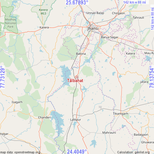
Tālbahat GPS coordinates[2]
25° 2' 36.852" North, 78° 26' 3.876" East
| Map corner | latitude | longitude |
|---|---|---|
| Upper-left | 25.67893°, | 77.73129° |
| Center: | 25.04357°, | 78.43441° |
| Lower-right: | 24.4049°, | 79.13754° |
| Map W x H: | 141.7×141.7 km | = 88×88mi |
| max Lat: | 34.9274° ⇑36.3% North |
| Tālbahat: | 25.04357° |
| min Lat: | ⇓63.7% South 8.09008° |
| min Long | Tālbahat | max Long |
| 68.82655° | 78.43441° | 96.81° |
| W 53.4%⇐ | ⇒46.6% E |
Elevation
Elevation of Tālbahat is 307 m = 1007 ft, and this is 11.4 m = 37 ft above average elevation for this country.
| Max E: |
3681 m = 12077 ft | 32.2% |
| Tālbahat | 307 m 1007 ft | |
| Avg. | 295.6 m = 970 ft | |
Min E: |
1 m = 3 ft | 67.8% |
See also: India elevation on elevation.city.
Geographical zone
Tālbahat is located in North temperate zone (between Tropic of Cancer and the Arctic Circle). Distance of this Northern Tropic circle is 178.7 km =111 mi to South.| Distance of | km | miles | from Tālbahat |
|---|---|---|---|
| North Pole | 7222.5 | 4487.9 | to North |
| Arctic Circle | 4616.6 | 2868.6 | to North |
| Tropic Cancer | 178.7 | 111 | to South |
| Equator | 2784.6 | 1730.3 | to South |


Nearby cities:
15 places around Tālbahat: (largest is in red/bold)
• Babīna
22.1 km =13.7 mi,  9°
9°
• Barāgaon
55.6 km =34.5 mi,  30°
30°
• Bāmor Kalān
33.1 km =20.6 mi,  239°
239°
• Chanderi
47.4 km =29.5 mi,  219°
219°
• Isāgarh
60.1 km =37.3 mi,  247°
247°
• Jatāra
62 km =38.5 mi,  93°
93°
• Jhānsi
48.4 km =30.1 mi,  17°
17°
• Karera
55 km =34.2 mi,  326°
326°
• Khailār
34.5 km =21.4 mi, 16°
• Lalitpur
39.3 km =24.4 mi,  182°
182°
• Mahroni
58.8 km =36.5 mi,  149°
149°
• Orchha
40.1 km =24.9 mi, 31°
• Pāli
61.4 km =38.2 mi, 181°
• Pārīchha
61.1 km =38 mi, 32°
• Tīkamgarh
52.1 km =32.4 mi,  129°
129°
Sources, notices
• [Note1] Compared only with cities in India existing in our database
• [Src1] Map data: © OpenStreetMap contributors (CC-BY-SA)
• [Src2] Other city data from geonames.org with taken over terms of usage.
• [Src3] Geographical zone / Annual Mean Temperature by Robert A. Rohde @ Wikipedia
