Lalitpur geodata
Lalitpur (Uttar Pradesh) is a populated place; located in India in Asia/Kolkata (GMT+5.5) time zone. With population of 126,475 people, there are 348 cities with bigger population in this country. Compared to other cities in India, 61.8% of cities are located further ↓South; 53.3% of cities are located further ←West and 72.8% of cities have lower elevation than Lalitpur. Note1


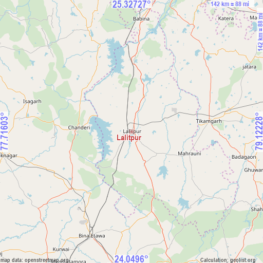
Lalitpur GPS coordinates[2]
24° 41' 24.252" North, 78° 25' 8.94" East
| Map corner | latitude | longitude |
|---|---|---|
| Upper-left | 25.32727°, | 77.71603° |
| Center: | 24.69007°, | 78.41915° |
| Lower-right: | 24.0496°, | 79.12228° |
| Map W x H: | 142.1×142.1 km | = 88.3×88.3mi |
| max Lat: | 34.9274° ⇑38.2% North |
| Lalitpur: | 24.69007° |
| min Lat: | ⇓61.8% South 8.09008° |
| min Long | Lalitpur | max Long |
| 68.82655° | 78.41915° | 96.81° |
| W 53.3%⇐ | ⇒46.7% E |
Elevation
Elevation of Lalitpur is 360 m = 1181 ft, and this is 64.4 m = 211 ft above average elevation for this country.
| Max E: |
3681 m = 12077 ft | 27.2% |
| Lalitpur | 360 m 1181 ft | |
| Avg. | 295.6 m = 970 ft | |
Min E: |
1 m = 3 ft | 72.8% |
See also: Lalitpur elevation on elevation.city.
Geographical zone
Lalitpur is located in North temperate zone (between Tropic of Cancer and the Arctic Circle). Distance of this Northern Tropic circle is 139.4 km =86.6 mi to South.| Distance of | km | miles | from Lalitpur |
|---|---|---|---|
| North Pole | 7261.8 | 4512.3 | to North |
| Arctic Circle | 4655.9 | 2893 | to North |
| Tropic Cancer | 139.4 | 86.6 | to South |
| Equator | 2745.3 | 1705.8 | to South |


Nearby cities:
15 places around Lalitpur: (largest is in red/bold)
• Ashoknagar
70.7 km =43.9 mi,  259°
259°
• Babīna
61.3 km =38.1 mi,  4°
4°
• Baldeogarh
65.9 km =40.9 mi,  83°
83°
• Bāmor Kalān
35.2 km =21.9 mi,  309°
309°
• Chanderi
28.5 km =17.7 mi,  275°
275°
• Etāwa
60.4 km =37.5 mi,  201°
201°
• Isāgarh
56.6 km =35.2 mi,  287°
287°
• Jatāra
72.8 km =45.2 mi,  60°
60°
• Khailār
73.3 km =45.5 mi,  8°
8°
• Khurai
72.4 km =45 mi,  187°
187°
• Mahroni
33.3 km =20.7 mi,  110°
110°
• Mungaoli
45.3 km =28.1 mi,  226°
226°
• Pāli
22 km =13.7 mi,  180°
180°
• Tālbahat
39.3 km =24.4 mi, 2°
• Tīkamgarh
42 km =26.1 mi, 81°
Sources, notices
• [Note1] Compared only with cities in India existing in our database
• [Src1] Map data: © OpenStreetMap contributors (CC-BY-SA)
• [Src2] Other city data from geonames.org with taken over terms of usage.
• [Src3] Geographical zone / Annual Mean Temperature by Robert A. Rohde @ Wikipedia
