Jatāra geodata
Jatāra (Madhya Pradesh) is a populated place; located in India in Asia/Kolkata (GMT+5.5) time zone. With population of 17,002 people, there are 2286 cities with bigger population in this country. Compared to other cities in India, 63.5% of cities are located further ↓South; 59.3% of cities are located further ←West and 61.5% of cities have lower elevation than Jatāra. Note1


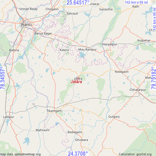
Jatāra GPS coordinates[2]
25° 0' 34.704" North, 79° 2' 55.284" East
| Map corner | latitude | longitude |
|---|---|---|
| Upper-left | 25.64517°, | 78.34557° |
| Center: | 25.00964°, | 79.04869° |
| Lower-right: | 24.3708°, | 79.75182° |
| Map W x H: | 141.7×141.7 km | = 88×88mi |
| max Lat: | 34.9274° ⇑36.5% North |
| Jatāra: | 25.00964° |
| min Lat: | ⇓63.5% South 8.09008° |
| min Long | Jatāra | max Long |
| 68.82655° | 79.04869° | 96.81° |
| W 59.3%⇐ | ⇒40.7% E |
Elevation
Elevation of Jatāra is 262 m = 860 ft, and this is 33.6 m = 110 ft below average elevation for this country.
| Max E: |
3681 m = 12077 ft | 38.5% |
| Avg. | 295.6 m = 970 ft | |
| Jatāra | 262 m = 860 ft | |
Min E: |
1 m = 3 ft | 61.5% |
See also: India elevation on elevation.city.
Geographical zone
Jatāra is located in North temperate zone (between Tropic of Cancer and the Arctic Circle). Distance of this Northern Tropic circle is 174.9 km =108.7 mi to South.| Distance of | km | miles | from Jatāra |
|---|---|---|---|
| North Pole | 7226.3 | 4490.2 | to North |
| Arctic Circle | 4620.4 | 2871 | to North |
| Tropic Cancer | 174.9 | 108.7 | to South |
| Equator | 2780.8 | 1727.9 | to South |


Nearby cities:
15 places around Jatāra: (largest is in red/bold)
• Babīna
63.6 km =39.5 mi,  293°
293°
• Baldeogarh
28.2 km =17.5 mi,  176°
176°
• Barāgaon
61.9 km =38.5 mi,  326°
326°
• Bijāwar
61.9 km =38.5 mi,  133°
133°
• Chhatarpur
55.4 km =34.4 mi,  100°
100°
• Harpālpur
42.1 km =26.2 mi,  42°
42°
• Khargāpur
22.9 km =14.2 mi,  155°
155°
• Mahroni
57.1 km =35.5 mi,  214°
214°
• Orchha
56 km =34.8 mi,  312°
312°
• Palera
18.1 km =11.2 mi,  86°
86°
• Pārīchha
62.6 km =38.9 mi, 332°
• Rānīpur
26.8 km =16.7 mi,  2°
2°
• Tori-Fatehpur
50 km =31.1 mi,  7°
7°
• Tālbahat
62 km =38.5 mi,  273°
273°
• Tīkamgarh
36.9 km =22.9 mi,  216°
216°
Sources, notices
• [Note1] Compared only with cities in India existing in our database
• [Src1] Map data: © OpenStreetMap contributors (CC-BY-SA)
• [Src2] Other city data from geonames.org with taken over terms of usage.
• [Src3] Geographical zone / Annual Mean Temperature by Robert A. Rohde @ Wikipedia
