Isāgarh geodata
Isāgarh (Madhya Pradesh) is a populated place; located in India in Asia/Kolkata (GMT+5.5) time zone. With population of 10,365 people, there are 2904 cities with bigger population in this country. Compared to other cities in India, 62.7% of cities are located further ↓South; 52.5% of cities are located further →East and 81.9% of cities have lower elevation than Isāgarh. Note1


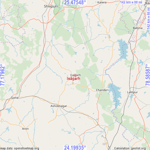
Isāgarh GPS coordinates[2]
24° 50' 20.616" North, 77° 52' 57.864" East
| Map corner | latitude | longitude |
|---|---|---|
| Upper-left | 25.47548°, | 77.17962° |
| Center: | 24.83906°, | 77.88274° |
| Lower-right: | 24.19935°, | 78.58587° |
| Map W x H: | 141.9×141.9 km | = 88.2×88.2mi |
| max Lat: | 34.9274° ⇑37.3% North |
| Isāgarh: | 24.83906° |
| min Lat: | ⇓62.7% South 8.09008° |
| min Long | Isāgarh | max Long |
| 68.82655° | 77.88274° | 96.81° |
| W 47.5%⇐ | ⇒52.5% E |
Elevation
Elevation of Isāgarh is 491 m = 1611 ft, and this is 195.4 m = 641 ft above average elevation for this country.
| Max E: |
3681 m = 12077 ft | 18.1% |
| Isāgarh | 491 m 1611 ft | |
| Avg. | 295.6 m = 970 ft | |
Min E: |
1 m = 3 ft | 81.9% |
See also: India elevation on elevation.city.
Geographical zone
Isāgarh is located in North temperate zone (between Tropic of Cancer and the Arctic Circle). Distance of this Northern Tropic circle is 155.9 km =96.9 mi to South.| Distance of | km | miles | from Isāgarh |
|---|---|---|---|
| North Pole | 7245.2 | 4502 | to North |
| Arctic Circle | 4639.3 | 2882.7 | to North |
| Tropic Cancer | 155.9 | 96.9 | to South |
| Equator | 2761.8 | 1716.1 | to South |


Nearby cities:
15 places around Isāgarh: (largest is in red/bold)
• Ashoknagar
33 km =20.5 mi,  207°
207°
• Babīna
74.1 km =46 mi,  53°
53°
• Badarwās
35.4 km =22 mi,  295°
295°
• Bijrauni
26.3 km =16.3 mi,  293°
293°
• Bāmor Kalān
27.7 km =17.2 mi,  77°
77°
• Chanderi
29.3 km =18.2 mi,  118°
118°
• Guna
61.5 km =38.2 mi,  249°
249°
• Karera
73.4 km =45.6 mi,  20°
20°
• Kolāras
50.3 km =31.3 mi,  327°
327°
• Lalitpur
56.6 km =35.2 mi,  107°
107°
• Mungaoli
52.5 km =32.6 mi,  155°
155°
• Pāli
66.3 km =41.2 mi,  125°
125°
• Shivpuri
68.7 km =42.7 mi,  341°
341°
• Tālbahat
60.1 km =37.3 mi,  67°
67°
• Āron
69.3 km =43.1 mi,  222°
222°
Sources, notices
• [Note1] Compared only with cities in India existing in our database
• [Src1] Map data: © OpenStreetMap contributors (CC-BY-SA)
• [Src2] Other city data from geonames.org with taken over terms of usage.
• [Src3] Geographical zone / Annual Mean Temperature by Robert A. Rohde @ Wikipedia
