Bāmor Kalān geodata
Bāmor Kalān (Madhya Pradesh) is a populated place; located in India in Asia/Kolkata (GMT+5.5) time zone. With population of 27,860 people, there are 1547 cities with bigger population in this country. Compared to other cities in India, 63% of cities are located further ↓South; 50.6% of cities are located further ←West and 72.5% of cities have lower elevation than Bāmor Kalān. Note1


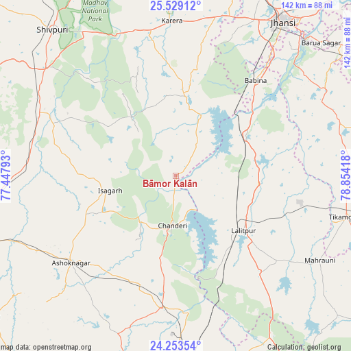
Bāmor Kalān GPS coordinates[2]
24° 53' 34.728" North, 78° 9' 3.78" East
| Map corner | latitude | longitude |
|---|---|---|
| Upper-left | 25.52912°, | 77.44793° |
| Center: | 24.89298°, | 78.15105° |
| Lower-right: | 24.25354°, | 78.85418° |
| Map W x H: | 141.8×141.8 km | = 88.1×88.1mi |
| max Lat: | 34.9274° ⇑37% North |
| Bāmor Kalān: | 24.89298° |
| min Lat: | ⇓63% South 8.09008° |
| min Long | Bāmor Kalān | max Long |
| 68.82655° | 78.15105° | 96.81° |
| W 50.6%⇐ | ⇒49.4% E |
Elevation
Elevation of Bāmor Kalān is 355 m = 1165 ft, and this is 59.4 m = 195 ft above average elevation for this country.
| Max E: |
3681 m = 12077 ft | 27.5% |
| Bāmor Kalān | 355 m 1165 ft | |
| Avg. | 295.6 m = 970 ft | |
Min E: |
1 m = 3 ft | 72.5% |
See also: India elevation on elevation.city.
Geographical zone
Bāmor Kalān is located in North temperate zone (between Tropic of Cancer and the Arctic Circle). Distance of this Northern Tropic circle is 161.9 km =100.6 mi to South.| Distance of | km | miles | from Bāmor Kalān |
|---|---|---|---|
| North Pole | 7239.2 | 4498.2 | to North |
| Arctic Circle | 4633.3 | 2879 | to North |
| Tropic Cancer | 161.9 | 100.6 | to South |
| Equator | 2767.8 | 1719.8 | to South |


Nearby cities:
15 places around Bāmor Kalān: (largest is in red/bold)
• Ashoknagar
55.1 km =34.2 mi,  230°
230°
• Babīna
50.2 km =31.2 mi,  39°
39°
• Badarwās
59.8 km =37.2 mi,  278°
278°
• Bijrauni
51.4 km =31.9 mi,  274°
274°
• Chanderi
20 km =12.4 mi,  183°
183°
• Isāgarh
27.7 km =17.2 mi,  257°
257°
• Karera
62.9 km =39.1 mi,  358°
358°
• Khailār
62.9 km =39.1 mi, 37°
• Kolāras
65.3 km =40.6 mi,  303°
303°
• Lalitpur
35.2 km =21.9 mi,  129°
129°
• Mahroni
67.5 km =41.9 mi,  120°
120°
• Mungaoli
54.2 km =33.7 mi,  185°
185°
• Pāli
52 km =32.3 mi,  149°
149°
• Tālbahat
33.1 km =20.6 mi,  59°
59°
• Tīkamgarh
70.6 km =43.9 mi,  103°
103°
Sources, notices
• [Note1] Compared only with cities in India existing in our database
• [Src1] Map data: © OpenStreetMap contributors (CC-BY-SA)
• [Src2] Other city data from geonames.org with taken over terms of usage.
• [Src3] Geographical zone / Annual Mean Temperature by Robert A. Rohde @ Wikipedia
