Chanderi geodata
Chanderi (Madhya Pradesh) is a populated place; located in India in Asia/Kolkata (GMT+5.5) time zone. With population of 32,549 people, there are 1338 cities with bigger population in this country. Compared to other cities in India, 61.9% of cities are located further ↓South; 50.4% of cities are located further ←West and 79.6% of cities have lower elevation than Chanderi. Note1


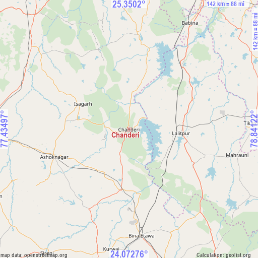
Chanderi GPS coordinates[2]
24° 42' 47.232" North, 78° 8' 17.124" East
| Map corner | latitude | longitude |
|---|---|---|
| Upper-left | 25.3502°, | 77.43497° |
| Center: | 24.71312°, | 78.13809° |
| Lower-right: | 24.07276°, | 78.84122° |
| Map W x H: | 142×142 km | = 88.2×88.2mi |
| max Lat: | 34.9274° ⇑38.1% North |
| Chanderi: | 24.71312° |
| min Lat: | ⇓61.9% South 8.09008° |
| min Long | Chanderi | max Long |
| 68.82655° | 78.13809° | 96.81° |
| W 50.4%⇐ | ⇒49.6% E |
Elevation
Elevation of Chanderi is 453 m = 1486 ft, and this is 157.4 m = 516 ft above average elevation for this country.
| Max E: |
3681 m = 12077 ft | 20.4% |
| Chanderi | 453 m 1486 ft | |
| Avg. | 295.6 m = 970 ft | |
Min E: |
1 m = 3 ft | 79.6% |
See also: India elevation on elevation.city.
Geographical zone
Chanderi is located in North temperate zone (between Tropic of Cancer and the Arctic Circle). Distance of this Northern Tropic circle is 141.9 km =88.2 mi to South.| Distance of | km | miles | from Chanderi |
|---|---|---|---|
| North Pole | 7259.2 | 4510.7 | to North |
| Arctic Circle | 4653.3 | 2891.4 | to North |
| Tropic Cancer | 141.9 | 88.2 | to South |
| Equator | 2747.8 | 1707.4 | to South |


Nearby cities:
15 places around Chanderi: (largest is in red/bold)
• Ashoknagar
43.9 km =27.3 mi,  249°
249°
• Babīna
67.4 km =41.9 mi,  29°
29°
• Badarwās
64.8 km =40.3 mi,  296°
296°
• Bamora
73.3 km =45.5 mi,  183°
183°
• Bijrauni
55.6 km =34.5 mi, 296°
• Bāmor Kalān
20 km =12.4 mi,  3°
3°
• Etāwa
59.3 km =36.8 mi,  173°
173°
• Isāgarh
29.3 km =18.2 mi, 298°
• Korwai
66.9 km =41.6 mi,  188°
188°
• Lalitpur
28.5 km =17.7 mi,  95°
95°
• Mahroni
61.2 km =38 mi, 103°
• Mungaoli
34.2 km =21.3 mi, 187°
• Pāli
37.4 km =23.2 mi,  131°
131°
• Tālbahat
47.4 km =29.5 mi,  39°
39°
• Tīkamgarh
70 km =43.5 mi,  87°
87°
Sources, notices
• [Note1] Compared only with cities in India existing in our database
• [Src1] Map data: © OpenStreetMap contributors (CC-BY-SA)
• [Src2] Other city data from geonames.org with taken over terms of usage.
• [Src3] Geographical zone / Annual Mean Temperature by Robert A. Rohde @ Wikipedia
