Valabhīpur geodata
Valabhīpur (Gujarat) is a populated place; located in India in Asia/Kolkata (GMT+5.5) time zone. With population of 18,663 people, there are 2157 cities with bigger population in this country. Compared to other cities in India, 57.1% of cities are located further ↑North; 97.5% of cities are located further →East and 88.1% of cities have higher elevation than Valabhīpur. Note1


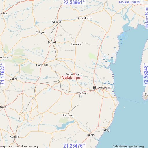
Valabhīpur GPS coordinates[2]
21° 53' 19.248" North, 71° 52' 45.66" East
| Map corner | latitude | longitude |
|---|---|---|
| Upper-left | 22.53961°, | 71.17623° |
| Center: | 21.88868°, | 71.87935° |
| Lower-right: | 21.23476°, | 72.58248° |
| Map W x H: | 145.1×145.1 km | = 90.2×90.2mi |
| max Lat: | 34.9274° ⇑57.1% North |
| Valabhīpur: | 21.88868° |
| min Lat: | ⇓42.9% South 8.09008° |
| min Long | Valabhīpur | max Long |
| 68.82655° | 71.87935° | 96.81° |
| W 2.5%⇐ | ⇒97.5% E |
Elevation
Elevation of Valabhīpur is 22 m = 72 ft, and this is 273.6 m = 898 ft below average elevation for this country.
| Max E: |
3681 m = 12077 ft | 88.1% |
| Avg. | 295.6 m = 970 ft | |
| Valabhīpur | 22 m = 72 ft | |
Min E: |
1 m = 3 ft | 11.9% |
See also: India elevation on elevation.city.
Geographical zone
Valabhīpur is located in North Torrid zone (between Equator and Tropic of Cancer). Distance of this Northern Tropic circle is 172.1 km =106.9 mi to North.| Distance of | km | miles | from Valabhīpur |
|---|---|---|---|
| North Pole | 7573.3 | 4705.8 | to North |
| Arctic Circle | 4967.4 | 3086.6 | to North |
| Tropic Cancer | 172.1 | 106.9 | to North |
| Equator | 2433.8 | 1512.3 | to South |


Nearby cities:
15 places around Valabhīpur: (largest is in red/bold)
• Bhavnagar
31.5 km =19.6 mi,  116°
116°
• Botād
38.1 km =23.7 mi,  324°
324°
• Bābra
59.4 km =36.9 mi,  265°
265°
• Dhandhuka
55.9 km =34.7 mi,  11°
11°
• Dhola
11 km =6.8 mi, 265°
• Dāmnagar
43.3 km =26.9 mi,  239°
239°
• Gadhada
32.3 km =20.1 mi,  286°
286°
• Gariadhar
49.9 km =31 mi,  218°
218°
• Ghogha
46.7 km =29 mi, 118°
• Lāthi
53.9 km =33.5 mi,  250°
250°
• Pālitāna
40.8 km =25.4 mi,  188°
188°
• Pāliyād
52.6 km =32.7 mi, 321°
• Sihor
21.5 km =13.4 mi,  156°
156°
• Umrāla
9.3 km =5.8 mi, 237°
• Vartej
25.4 km =15.8 mi,  130°
130°
Sources, notices
• [Note1] Compared only with cities in India existing in our database
• [Src1] Map data: © OpenStreetMap contributors (CC-BY-SA)
• [Src2] Other city data from geonames.org with taken over terms of usage.
• [Src3] Geographical zone / Annual Mean Temperature by Robert A. Rohde @ Wikipedia
