Vartej geodata
Vartej (Gujarat) is a populated place; located in India in Asia/Kolkata (GMT+5.5) time zone. With population of 10,271 people, there are 2914 cities with bigger population in this country. Compared to other cities in India, 57.7% of cities are located further ↑North; 97.3% of cities are located further →East and 84.7% of cities have higher elevation than Vartej. Note1


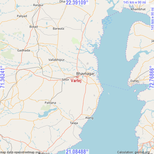
Vartej GPS coordinates[2]
21° 44' 22.092" North, 72° 3' 55.908" East
| Map corner | latitude | longitude |
|---|---|---|
| Upper-left | 22.39109°, | 71.36241° |
| Center: | 21.73947°, | 72.06553° |
| Lower-right: | 21.08488°, | 72.76866° |
| Map W x H: | 145.2×145.2 km | = 90.2×90.2mi |
| max Lat: | 34.9274° ⇑57.7% North |
| Vartej: | 21.73947° |
| min Lat: | ⇓42.3% South 8.09008° |
| min Long | Vartej | max Long |
| 68.82655° | 72.06553° | 96.81° |
| W 2.7%⇐ | ⇒97.3% E |
Elevation
Elevation of Vartej is 31 m = 102 ft, and this is 264.6 m = 868 ft below average elevation for this country.
| Max E: |
3681 m = 12077 ft | 84.7% |
| Avg. | 295.6 m = 970 ft | |
| Vartej | 31 m = 102 ft | |
Min E: |
1 m = 3 ft | 15.3% |
See also: India elevation on elevation.city.
Geographical zone
Vartej is located in North Torrid zone (between Equator and Tropic of Cancer). Distance of this Northern Tropic circle is 188.7 km =117.3 mi to North.| Distance of | km | miles | from Vartej |
|---|---|---|---|
| North Pole | 7589.9 | 4716.1 | to North |
| Arctic Circle | 4984 | 3096.9 | to North |
| Tropic Cancer | 188.7 | 117.3 | to North |
| Equator | 2417.2 | 1502 | to South |


Nearby cities:
15 places around Vartej: (largest is in red/bold)
• Bhavnagar
9.4 km =5.8 mi,  73°
73°
• Botād
63 km =39.1 mi,  319°
319°
• Dhandhuka
71.9 km =44.7 mi,  353°
353°
• Dhola
34.1 km =21.2 mi,  297°
297°
• Dungarpur
59.6 km =37 mi,  212°
212°
• Dāmnagar
56.9 km =35.4 mi,  264°
264°
• Gadhada
56.4 km =35 mi, 296°
• Gariadhar
55.2 km =34.3 mi,  246°
246°
• Ghogha
22.5 km =14 mi,  104°
104°
• Lāthi
70 km =43.5 mi,  268°
268°
• Pālitāna
34.6 km =21.5 mi,  226°
226°
• Sihor
11.2 km =7 mi, 253°
• Talāja
43.1 km =26.8 mi,  184°
184°
• Umrāla
29.5 km =18.3 mi,  293°
293°
• Valabhīpur
25.4 km =15.8 mi,  310°
310°
Sources, notices
• [Note1] Compared only with cities in India existing in our database
• [Src1] Map data: © OpenStreetMap contributors (CC-BY-SA)
• [Src2] Other city data from geonames.org with taken over terms of usage.
• [Src3] Geographical zone / Annual Mean Temperature by Robert A. Rohde @ Wikipedia
