Ghogha geodata
Ghogha (Gujarat) is a populated place; located in India in Asia/Kolkata (GMT+5.5) time zone. With population of 11,361 people, there are 2799 cities with bigger population in this country. Compared to other cities in India, 58.1% of cities are located further ↑North; 97.1% of cities are located further →East and 96.4% of cities have higher elevation than Ghogha. Note1


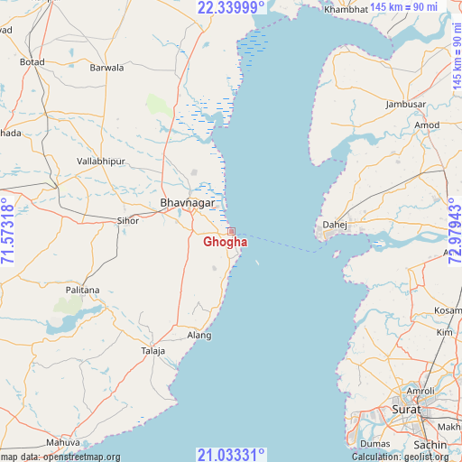
Ghogha GPS coordinates[2]
21° 41' 17.268" North, 72° 16' 34.68" East
| Map corner | latitude | longitude |
|---|---|---|
| Upper-left | 22.33999°, | 71.57318° |
| Center: | 21.68813°, | 72.2763° |
| Lower-right: | 21.03331°, | 72.97943° |
| Map W x H: | 145.3×145.3 km | = 90.3×90.3mi |
| max Lat: | 34.9274° ⇑58.1% North |
| Ghogha: | 21.68813° |
| min Lat: | ⇓41.9% South 8.09008° |
| min Long | Ghogha | max Long |
| 68.82655° | 72.2763° | 96.81° |
| W 2.9%⇐ | ⇒97.1% E |
Elevation
Elevation of Ghogha is 10 m = 33 ft, and this is 285.6 m = 937 ft below average elevation for this country.
| Max E: |
3681 m = 12077 ft | 96.4% |
| Avg. | 295.6 m = 970 ft | |
| Ghogha | 10 m = 33 ft | |
Min E: |
1 m = 3 ft | 3.6% |
See also: India elevation on elevation.city.
Geographical zone
Ghogha is located in North Torrid zone (between Equator and Tropic of Cancer). Distance of this Northern Tropic circle is 194.4 km =120.8 mi to North.| Distance of | km | miles | from Ghogha |
|---|---|---|---|
| North Pole | 7595.6 | 4719.7 | to North |
| Arctic Circle | 4989.7 | 3100.5 | to North |
| Tropic Cancer | 194.4 | 120.8 | to North |
| Equator | 2411.5 | 1498.4 | to South |


Nearby cities:
15 places around Ghogha: (largest is in red/bold)
• Amod
70.1 km =43.6 mi,  61°
61°
• Ankleshwar
74 km =46 mi,  94°
94°
• Bharūch
72.8 km =45.2 mi, 89°
• Bhavnagar
15.2 km =9.4 mi,  303°
303°
• Dhola
56.3 km =35 mi,  292°
292°
• Dungarpur
69.9 km =43.4 mi,  230°
230°
• Hansot
56.1 km =34.9 mi,  101°
101°
• Jambusar
67.6 km =42 mi,  53°
53°
• Olpād
62.8 km =39 mi,  128°
128°
• Pālitāna
50.2 km =31.2 mi,  248°
248°
• Sihor
32.6 km =20.3 mi,  274°
274°
• Talāja
44.9 km =27.9 mi,  213°
213°
• Umrāla
51.8 km =32.2 mi, 289°
• Valabhīpur
46.7 km =29 mi, 298°
• Vartej
22.5 km =14 mi,  284°
284°
Sources, notices
• [Note1] Compared only with cities in India existing in our database
• [Src1] Map data: © OpenStreetMap contributors (CC-BY-SA)
• [Src2] Other city data from geonames.org with taken over terms of usage.
• [Src3] Geographical zone / Annual Mean Temperature by Robert A. Rohde @ Wikipedia
