Dhola geodata
Dhola (Gujarat) is a populated place; located in India in Asia/Kolkata (GMT+5.5) time zone. With population of 8,206 people, there are 3109 cities with bigger population in this country. Compared to other cities in India, 57.1% of cities are located further ↑North; 97.7% of cities are located further →East and 83.5% of cities have higher elevation than Dhola. Note1


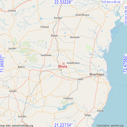
Dhola GPS coordinates[2]
21° 52' 52.644" North, 71° 46' 21.684" East
| Map corner | latitude | longitude |
|---|---|---|
| Upper-left | 22.53226°, | 71.06957° |
| Center: | 21.88129°, | 71.77269° |
| Lower-right: | 21.22734°, | 72.47582° |
| Map W x H: | 145.1×145.1 km | = 90.2×90.2mi |
| max Lat: | 34.9274° ⇑57.1% North |
| Dhola: | 21.88129° |
| min Lat: | ⇓42.9% South 8.09008° |
| min Long | Dhola | max Long |
| 68.82655° | 71.77269° | 96.81° |
| W 2.3%⇐ | ⇒97.7% E |
Elevation
Elevation of Dhola is 35 m = 115 ft, and this is 260.6 m = 855 ft below average elevation for this country.
| Max E: |
3681 m = 12077 ft | 83.5% |
| Avg. | 295.6 m = 970 ft | |
| Dhola | 35 m = 115 ft | |
Min E: |
1 m = 3 ft | 16.5% |
See also: India elevation on elevation.city.
Geographical zone
Dhola is located in North Torrid zone (between Equator and Tropic of Cancer). Distance of this Northern Tropic circle is 172.9 km =107.4 mi to North.| Distance of | km | miles | from Dhola |
|---|---|---|---|
| North Pole | 7574.1 | 4706.3 | to North |
| Arctic Circle | 4968.2 | 3087.1 | to North |
| Tropic Cancer | 172.9 | 107.4 | to North |
| Equator | 2433 | 1511.8 | to South |


Nearby cities:
15 places around Dhola: (largest is in red/bold)
• Bhavnagar
41.4 km =25.7 mi,  108°
108°
• Botād
33.8 km =21 mi,  341°
341°
• Bābra
48.4 km =30.1 mi,  265°
265°
• Dāmnagar
33.7 km =20.9 mi,  231°
231°
• Gadhada
22.3 km =13.9 mi,  296°
296°
• Gariadhar
43.1 km =26.8 mi,  207°
207°
• Ghogha
56.3 km =35 mi, 112°
• Lāthi
43.4 km =27 mi,  246°
246°
• Pālitāna
39.9 km =24.8 mi,  172°
172°
• Pāliyād
47.2 km =29.3 mi,  332°
332°
• Sihor
27.2 km =16.9 mi,  134°
134°
• Umrāla
5.2 km =3.2 mi,  143°
143°
• Valabhīpur
11 km =6.8 mi,  85°
85°
• Vartej
34.1 km =21.2 mi,  117°
117°
• Vinchia
54.6 km =33.9 mi,  312°
312°
Sources, notices
• [Note1] Compared only with cities in India existing in our database
• [Src1] Map data: © OpenStreetMap contributors (CC-BY-SA)
• [Src2] Other city data from geonames.org with taken over terms of usage.
• [Src3] Geographical zone / Annual Mean Temperature by Robert A. Rohde @ Wikipedia
