Patiāla geodata
Patiāla (Punjab) is a populated place; located in India in Asia/Kolkata (GMT+5.5) time zone. With population of 329,224 people, there are 130 cities with bigger population in this country. Compared to other cities in India, 93.9% of cities are located further ↓South; 69.3% of cities are located further →East and 61% of cities have lower elevation than Patiāla. Note1


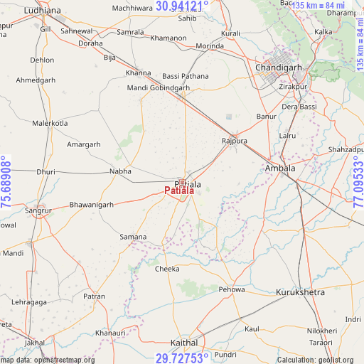
Patiāla GPS coordinates[2]
30° 20' 10.5" North, 76° 23' 31.92" East
| Map corner | latitude | longitude |
|---|---|---|
| Upper-left | 30.94121°, | 75.68908° |
| Center: | 30.33625°, | 76.3922° |
| Lower-right: | 29.72753°, | 77.09533° |
| Map W x H: | 134.9×135 km | = 83.8×83.9mi |
| max Lat: | 34.9274° ⇑6.1% North |
| Patiāla: | 30.33625° |
| min Lat: | ⇓93.9% South 8.09008° |
| min Long | Patiāla | max Long |
| 68.82655° | 76.3922° | 96.81° |
| W 30.7%⇐ | ⇒69.3% E |
Elevation
Elevation of Patiāla is 258 m = 846 ft, and this is 37.6 m = 123 ft below average elevation for this country.
| Max E: |
3681 m = 12077 ft | 39% |
| Avg. | 295.6 m = 970 ft | |
| Patiāla | 258 m = 846 ft | |
Min E: |
1 m = 3 ft | 61% |
See also: Patiāla elevation on elevation.city.
Geographical zone
Patiāla is located in North temperate zone (between Tropic of Cancer and the Arctic Circle). Distance of this Northern Tropic circle is 767.2 km =476.7 mi to South.| Distance of | km | miles | from Patiāla |
|---|---|---|---|
| North Pole | 6634 | 4122.2 | to North |
| Arctic Circle | 4028.1 | 2502.9 | to North |
| Tropic Cancer | 767.2 | 476.7 | to South |
| Equator | 3373.1 | 2095.9 | to South |


Nearby cities:
15 places around Patiāla: (largest is in red/bold)
• Ambāla
39 km =24.2 mi,  85°
85°
• Amloh
33.9 km =21.1 mi,  333°
333°
• Banūr
39.6 km =24.6 mi,  52°
52°
• Basi
39.2 km =24.4 mi,  1°
1°
• Bhawānīgarh
34.8 km =21.6 mi,  257°
257°
• Chīma
48.6 km =30.2 mi,  322°
322°
• Dirba
48.1 km =29.9 mi,  232°
232°
• Ghanaur
21.1 km =13.1 mi, 91°
• Khanna
44.2 km =27.5 mi,  338°
338°
• Mohali
49.6 km =30.8 mi,  39°
39°
• Nābha
23.4 km =14.5 mi,  280°
280°
• Pehowa
43.7 km =27.2 mi,  155°
155°
• Rājpura
24.9 km =15.5 mi, 50°
• Sanaur
7.4 km =4.6 mi,  121°
121°
• Sirhind
34.1 km =21.2 mi,  358°
358°
Sources, notices
• [Note1] Compared only with cities in India existing in our database
• [Src1] Map data: © OpenStreetMap contributors (CC-BY-SA)
• [Src2] Other city data from geonames.org with taken over terms of usage.
• [Src3] Geographical zone / Annual Mean Temperature by Robert A. Rohde @ Wikipedia
