Banūr geodata
Banūr (Punjab) is a populated place; located in India in Asia/Kolkata (GMT+5.5) time zone. With population of 17,349 people, there are 2253 cities with bigger population in this country. Compared to other cities in India, 94.4% of cities are located further ↓South; 66.1% of cities are located further →East and 65.2% of cities have lower elevation than Banūr. Note1


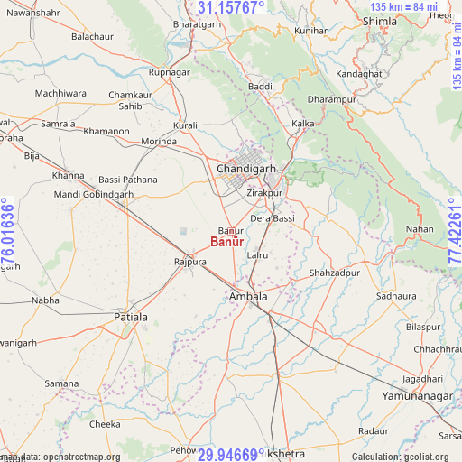
Banūr GPS coordinates[2]
30° 33' 14.652" North, 76° 43' 10.128" East
| Map corner | latitude | longitude |
|---|---|---|
| Upper-left | 31.15767°, | 76.01636° |
| Center: | 30.55407°, | 76.71948° |
| Lower-right: | 29.94669°, | 77.42261° |
| Map W x H: | 134.6×134.6 km | = 83.6×83.6mi |
| max Lat: | 34.9274° ⇑5.6% North |
| Banūr: | 30.55407° |
| min Lat: | ⇓94.4% South 8.09008° |
| min Long | Banūr | max Long |
| 68.82655° | 76.71948° | 96.81° |
| W 33.9%⇐ | ⇒66.1% E |
Elevation
Elevation of Banūr is 287 m = 942 ft, and this is 8.6 m = 28 ft below average elevation for this country.
| Max E: |
3681 m = 12077 ft | 34.8% |
| Avg. | 295.6 m = 970 ft | |
| Banūr | 287 m = 942 ft | |
Min E: |
1 m = 3 ft | 65.2% |
See also: India elevation on elevation.city.
Geographical zone
Banūr is located in North temperate zone (between Tropic of Cancer and the Arctic Circle). Distance of this Northern Tropic circle is 791.4 km =491.8 mi to South.| Distance of | km | miles | from Banūr |
|---|---|---|---|
| North Pole | 6609.8 | 4107.1 | to North |
| Arctic Circle | 4003.9 | 2487.9 | to North |
| Tropic Cancer | 791.4 | 491.8 | to South |
| Equator | 3397.3 | 2111 | to South |


Nearby cities:
15 places around Banūr: (largest is in red/bold)
• Ambāla
22.7 km =14.1 mi,  160°
160°
• Basi
12.6 km =7.8 mi,  72°
72°
• Basi
33.9 km =21.1 mi,  296°
296°
• Chandigarh
21.3 km =13.2 mi,  18°
18°
• Ghanaur
26.9 km =16.7 mi,  202°
202°
• Kharar
22.5 km =14 mi,  342°
342°
• Kālka
38.2 km =23.7 mi,  33°
33°
• Mohali
14 km =8.7 mi,  1°
1°
• Morinda
33.7 km =20.9 mi,  321°
321°
• Panchkula
20 km =12.4 mi,  38°
38°
• Parwanoo
39.1 km =24.3 mi, 36°
• Pinjaur
33.2 km =20.6 mi, 34°
• Rājpura
14.8 km =9.2 mi,  235°
235°
• Sanaur
37.6 km =23.4 mi,  221°
221°
• Sirhind
33.6 km =20.9 mi,  287°
287°
Sources, notices
• [Note1] Compared only with cities in India existing in our database
• [Src1] Map data: © OpenStreetMap contributors (CC-BY-SA)
• [Src2] Other city data from geonames.org with taken over terms of usage.
• [Src3] Geographical zone / Annual Mean Temperature by Robert A. Rohde @ Wikipedia
