Rājpura geodata
Rājpura (Punjab) is a populated place; located in India in Asia/Kolkata (GMT+5.5) time zone. With population of 86,820 people, there are 515 cities with bigger population in this country. Compared to other cities in India, 94.4% of cities are located further ↓South; 67.3% of cities are located further →East and 63.2% of cities have lower elevation than Rājpura. Note1


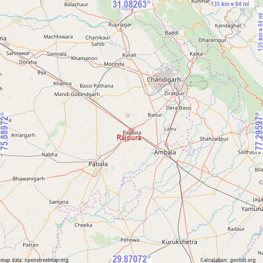
Rājpura GPS coordinates[2]
30° 28' 42.816" North, 76° 35' 34.224" East
| Map corner | latitude | longitude |
|---|---|---|
| Upper-left | 31.08263°, | 75.88972° |
| Center: | 30.47856°, | 76.59284° |
| Lower-right: | 29.87072°, | 77.29597° |
| Map W x H: | 134.8×134.8 km | = 83.8×83.8mi |
| max Lat: | 34.9274° ⇑5.6% North |
| Rājpura: | 30.47856° |
| min Lat: | ⇓94.4% South 8.09008° |
| min Long | Rājpura | max Long |
| 68.82655° | 76.59284° | 96.81° |
| W 32.7%⇐ | ⇒67.3% E |
Elevation
Elevation of Rājpura is 273 m = 896 ft, and this is 22.6 m = 74 ft below average elevation for this country.
| Max E: |
3681 m = 12077 ft | 36.8% |
| Avg. | 295.6 m = 970 ft | |
| Rājpura | 273 m = 896 ft | |
Min E: |
1 m = 3 ft | 63.2% |
See also: Rājpura elevation on elevation.city.
Geographical zone
Rājpura is located in North temperate zone (between Tropic of Cancer and the Arctic Circle). Distance of this Northern Tropic circle is 783 km =486.5 mi to South.| Distance of | km | miles | from Rājpura |
|---|---|---|---|
| North Pole | 6618.2 | 4112.4 | to North |
| Arctic Circle | 4012.3 | 2493.1 | to North |
| Tropic Cancer | 783 | 486.5 | to South |
| Equator | 3388.9 | 2105.8 | to South |


Nearby cities:
15 places around Rājpura: (largest is in red/bold)
• Ambāla
23.6 km =14.7 mi,  123°
123°
• Amloh
37.4 km =23.2 mi,  292°
292°
• Banūr
14.8 km =9.2 mi,  55°
55°
• Basi
27 km =16.8 mi, 63°
• Basi
29.7 km =18.5 mi,  321°
321°
• Chandigarh
34.2 km =21.3 mi,  33°
33°
• Ghanaur
16.5 km =10.3 mi,  173°
173°
• Kharar
30.2 km =18.8 mi,  9°
9°
• Mohali
25.6 km =15.9 mi, 28°
• Morinda
35.8 km =22.2 mi,  345°
345°
• Panchkula
34.4 km =21.4 mi,  45°
45°
• Patiāla
24.9 km =15.5 mi,  230°
230°
• Sanaur
23.5 km =14.6 mi,  213°
213°
• Shāhābād
43.6 km =27.1 mi,  142°
142°
• Sirhind
27.1 km =16.8 mi,  312°
312°
Sources, notices
• [Note1] Compared only with cities in India existing in our database
• [Src1] Map data: © OpenStreetMap contributors (CC-BY-SA)
• [Src2] Other city data from geonames.org with taken over terms of usage.
• [Src3] Geographical zone / Annual Mean Temperature by Robert A. Rohde @ Wikipedia
