Mohali geodata
Mohali (Punjab) is a populated place; located in India in Asia/Kolkata (GMT+5.5) time zone. With population of 123,484 people, there are 354 cities with bigger population in this country. Compared to other cities in India, 94.7% of cities are located further ↓South; 66.1% of cities are located further →East and 68.6% of cities have lower elevation than Mohali. Note1


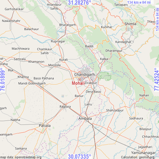
Mohali GPS coordinates[2]
30° 40' 47.82" North, 76° 43' 19.596" East
| Map corner | latitude | longitude |
|---|---|---|
| Upper-left | 31.28276°, | 76.01899° |
| Center: | 30.67995°, | 76.72211° |
| Lower-right: | 30.07335°, | 77.42524° |
| Map W x H: | 134.5×134.5 km | = 83.6×83.6mi |
| max Lat: | 34.9274° ⇑5.3% North |
| Mohali: | 30.67995° |
| min Lat: | ⇓94.7% South 8.09008° |
| min Long | Mohali | max Long |
| 68.82655° | 76.72211° | 96.81° |
| W 33.9%⇐ | ⇒66.1% E |
Elevation
Elevation of Mohali is 312 m = 1024 ft, and this is 16.4 m = 54 ft above average elevation for this country.
| Max E: |
3681 m = 12077 ft | 31.4% |
| Mohali | 312 m 1024 ft | |
| Avg. | 295.6 m = 970 ft | |
Min E: |
1 m = 3 ft | 68.6% |
See also: Mohali elevation on elevation.city.
Geographical zone
Mohali is located in North temperate zone (between Tropic of Cancer and the Arctic Circle). Distance of this Northern Tropic circle is 805.4 km =500.5 mi to South.| Distance of | km | miles | from Mohali |
|---|---|---|---|
| North Pole | 6595.8 | 4098.4 | to North |
| Arctic Circle | 3989.9 | 2479.2 | to North |
| Tropic Cancer | 805.4 | 500.5 | to South |
| Equator | 3411.3 | 2119.7 | to South |


Nearby cities:
15 places around Mohali: (largest is in red/bold)
• Ambāla
36.2 km =22.5 mi,  168°
168°
• Baddi
31.6 km =19.6 mi,  12°
12°
• Banūr
14 km =8.7 mi,  181°
181°
• Basi
15.6 km =9.7 mi,  130°
130°
• Basi
30.7 km =19.1 mi,  271°
271°
• Chandigarh
8.9 km =5.5 mi,  45°
45°
• Kasauli
33.7 km =20.9 mi,  43°
43°
• Kharar
10.3 km =6.4 mi,  315°
315°
• Kālka
27.4 km =17 mi, 49°
• Morinda
24.6 km =15.3 mi,  299°
299°
• Panchkula
12.4 km =7.7 mi,  82°
82°
• Parwanoo
28.8 km =17.9 mi, 52°
• Pinjaur
22.9 km =14.2 mi, 54°
• Rājpura
25.6 km =15.9 mi,  208°
208°
• Sirhind
32.6 km =20.3 mi,  262°
262°
Sources, notices
• [Note1] Compared only with cities in India existing in our database
• [Src1] Map data: © OpenStreetMap contributors (CC-BY-SA)
• [Src2] Other city data from geonames.org with taken over terms of usage.
• [Src3] Geographical zone / Annual Mean Temperature by Robert A. Rohde @ Wikipedia
