Sanaur geodata
Sanaur (Punjab) is a populated place; located in India in Asia/Kolkata (GMT+5.5) time zone. With population of 18,401 people, there are 2170 cities with bigger population in this country. Compared to other cities in India, 93.8% of cities are located further ↓South; 68.9% of cities are located further →East and 62.1% of cities have lower elevation than Sanaur. Note1


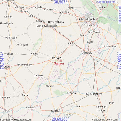
Sanaur GPS coordinates[2]
30° 18' 6.552" North, 76° 27' 28.296" East
| Map corner | latitude | longitude |
|---|---|---|
| Upper-left | 30.907°, | 75.75474° |
| Center: | 30.30182°, | 76.45786° |
| Lower-right: | 29.69288°, | 77.16099° |
| Map W x H: | 135×135 km | = 83.9×83.9mi |
| max Lat: | 34.9274° ⇑6.2% North |
| Sanaur: | 30.30182° |
| min Lat: | ⇓93.8% South 8.09008° |
| min Long | Sanaur | max Long |
| 68.82655° | 76.45786° | 96.81° |
| W 31.1%⇐ | ⇒68.9% E |
Elevation
Elevation of Sanaur is 265 m = 869 ft, and this is 30.6 m = 100 ft below average elevation for this country.
| Max E: |
3681 m = 12077 ft | 37.9% |
| Avg. | 295.6 m = 970 ft | |
| Sanaur | 265 m = 869 ft | |
Min E: |
1 m = 3 ft | 62.1% |
See also: India elevation on elevation.city.
Geographical zone
Sanaur is located in North temperate zone (between Tropic of Cancer and the Arctic Circle). Distance of this Northern Tropic circle is 763.3 km =474.3 mi to South.| Distance of | km | miles | from Sanaur |
|---|---|---|---|
| North Pole | 6637.8 | 4124.5 | to North |
| Arctic Circle | 4031.9 | 2505.3 | to North |
| Tropic Cancer | 763.3 | 474.3 | to South |
| Equator | 3369.2 | 2093.5 | to South |


Nearby cities:
15 places around Sanaur: (largest is in red/bold)
• Ambāla
33.3 km =20.7 mi,  78°
78°
• Amloh
40.4 km =25.1 mi,  327°
327°
• Banūr
37.6 km =23.4 mi,  41°
41°
• Basi
43.3 km =26.9 mi,  352°
352°
• Basi
48.9 km =30.4 mi,  49°
49°
• Bhawānīgarh
40.4 km =25.1 mi,  264°
264°
• Ghanaur
15.1 km =9.4 mi, 77°
• Khanna
50.3 km =31.3 mi, 333°
• Mohali
49.1 km =30.5 mi,  31°
31°
• Nābha
30.4 km =18.9 mi,  285°
285°
• Patiāla
7.4 km =4.6 mi,  301°
301°
• Pehowa
37.8 km =23.5 mi,  161°
161°
• Rājpura
23.5 km =14.6 mi, 33°
• Shāhābād
42.3 km =26.3 mi,  110°
110°
• Sirhind
38.6 km =24 mi, 349°
Sources, notices
• [Note1] Compared only with cities in India existing in our database
• [Src1] Map data: © OpenStreetMap contributors (CC-BY-SA)
• [Src2] Other city data from geonames.org with taken over terms of usage.
• [Src3] Geographical zone / Annual Mean Temperature by Robert A. Rohde @ Wikipedia
