Bengaluru geodata
Bengaluru (Karnataka) is a seat of a first-order administrative division; located in India in Asia/Kolkata (GMT+5.5) time zone. With population of 5,104,047 people, there are 2 cities with bigger population in this country. Compared to other cities in India, 86.5% of cities are located further ↑North; 56.2% of cities are located further →East and 95.5% of cities have lower elevation than Bengaluru. Note1


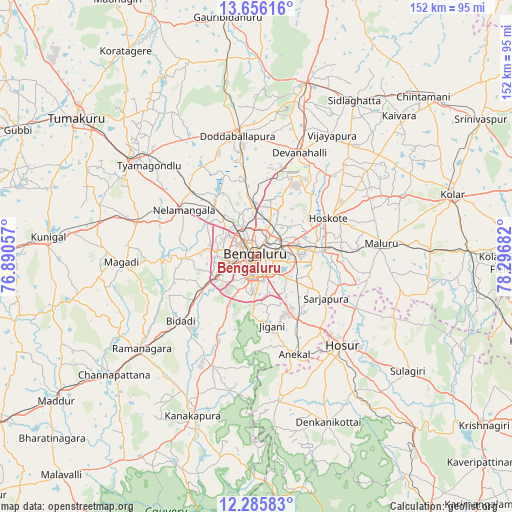
Bengaluru GPS coordinates[2]
12° 58' 18.984" North, 77° 35' 37.284" East
| Map corner | latitude | longitude |
|---|---|---|
| Upper-left | 13.65616°, | 76.89057° |
| Center: | 12.97194°, | 77.59369° |
| Lower-right: | 12.28583°, | 78.29682° |
| Map W x H: | 152.4×152.4 km | = 94.7×94.7mi |
| max Lat: | 34.9274° ⇑86.5% North |
| Bengaluru: | 12.97194° |
| min Lat: | ⇓13.5% South 8.09008° |
| min Long | Bengaluru | max Long |
| 68.82655° | 77.59369° | 96.81° |
| W 43.8%⇐ | ⇒56.2% E |
Elevation
Elevation of Bengaluru is 914 m = 2999 ft, and this is 618.4 m = 2029 ft above average elevation for this country.
| Max E: |
3681 m = 12077 ft | 4.5% |
| Bengaluru | 914 m 2999 ft | |
| Avg. | 295.6 m = 970 ft | |
Min E: |
1 m = 3 ft | 95.5% |
See also: Bengaluru elevation on elevation.city.
Geographical zone
Bengaluru is located in North Torrid zone (between Equator and Tropic of Cancer). Distance of this Northern Tropic circle is 1163.6 km =723 mi to North.| Distance of | km | miles | from Bengaluru |
|---|---|---|---|
| North Pole | 8564.7 | 5321.9 | to North |
| Arctic Circle | 5958.8 | 3702.6 | to North |
| Tropic Cancer | 1163.6 | 723 | to North |
| Equator | 1442.3 | 896.2 | to South |


Nearby cities:
15 places around Bengaluru: (largest is in red/bold)
• Anekal
31 km =19.3 mi,  159°
159°
• Chik Ballāpur
53.5 km =33.2 mi,  15°
15°
• Closepet
43.8 km =27.2 mi,  230°
230°
• Dasarahalli
29.4 km =18.3 mi,  61°
61°
• Devanhalli
33.1 km =20.6 mi, 22°
• Dod Ballāpur
36.4 km =22.6 mi,  350°
350°
• Hoskote
24.7 km =15.3 mi, 63°
• Hosūr
36.8 km =22.9 mi,  135°
135°
• Kelamangalam
49.7 km =30.9 mi,  145°
145°
• Kānkānhalli
50.9 km =31.6 mi,  201°
201°
• Māgadi
40.1 km =24.9 mi,  267°
267°
• Mālūr
37.5 km =23.3 mi,  84°
84°
• Nelamangala
25.9 km =16.1 mi,  303°
303°
• Vadigenhalli
42.6 km =26.5 mi,  31°
31°
• Yelahanka
14.3 km =8.9 mi,  1°
1°
In other languages:
- In Spanish: Bangalore
- In France: Bangalore
- In Italian: Bangalore
- In Russian: Бангалор
- In Chinese: 班加羅爾
Sources, notices
• [Note1] Compared only with cities in India existing in our database
• [Src1] Map data: © OpenStreetMap contributors (CC-BY-SA)
• [Src2] Other city data from geonames.org with taken over terms of usage.
• [Src3] Geographical zone / Annual Mean Temperature by Robert A. Rohde @ Wikipedia
