Hoskote geodata
Hoskote (Karnataka) is a populated place; located in India in Asia/Kolkata (GMT+5.5) time zone. With population of 41,236 people, there are 1072 cities with bigger population in this country. Compared to other cities in India, 86% of cities are located further ↑North; 53.6% of cities are located further →East and 95.1% of cities have lower elevation than Hoskote. Note1


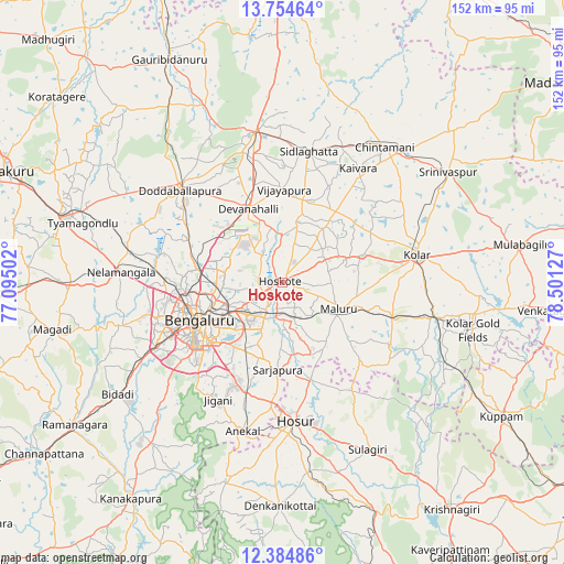
Hoskote GPS coordinates[2]
13° 4' 14.52" North, 77° 47' 53.304" East
| Map corner | latitude | longitude |
|---|---|---|
| Upper-left | 13.75464°, | 77.09502° |
| Center: | 13.0707°, | 77.79814° |
| Lower-right: | 12.38486°, | 78.50127° |
| Map W x H: | 152.3×152.3 km | = 94.6×94.6mi |
| max Lat: | 34.9274° ⇑86% North |
| Hoskote: | 13.0707° |
| min Lat: | ⇓14% South 8.09008° |
| min Long | Hoskote | max Long |
| 68.82655° | 77.79814° | 96.81° |
| W 46.4%⇐ | ⇒53.6% E |
Elevation
Elevation of Hoskote is 884 m = 2900 ft, and this is 588.4 m = 1930 ft above average elevation for this country.
| Max E: |
3681 m = 12077 ft | 4.9% |
| Hoskote | 884 m 2900 ft | |
| Avg. | 295.6 m = 970 ft | |
Min E: |
1 m = 3 ft | 95.1% |
See also: Hoskote elevation on elevation.city.
Geographical zone
Hoskote is located in North Torrid zone (between Equator and Tropic of Cancer). Distance of this Northern Tropic circle is 1152.6 km =716.2 mi to North.| Distance of | km | miles | from Hoskote |
|---|---|---|---|
| North Pole | 8553.7 | 5315 | to North |
| Arctic Circle | 5947.8 | 3695.8 | to North |
| Tropic Cancer | 1152.6 | 716.2 | to North |
| Equator | 1453.3 | 903 | to South |


Nearby cities:
15 places around Hoskote: (largest is in red/bold)
• Anekal
41.5 km =25.8 mi,  195°
195°
• Bangarapet
42.1 km =26.2 mi,  102°
102°
• Bengaluru
24.7 km =15.3 mi,  243°
243°
• Chik Ballāpur
41.2 km =25.6 mi,  349°
349°
• Chintāmani
45.8 km =28.5 mi,  36°
36°
• Dasarahalli
4.8 km =3 mi,  49°
49°
• Devanhalli
21.7 km =13.5 mi,  334°
334°
• Dod Ballāpur
37.6 km =23.4 mi,  311°
311°
• Hosūr
37.4 km =23.2 mi,  174°
174°
• Kolār
36.7 km =22.8 mi,  78°
78°
• Mālūr
16.9 km =10.5 mi,  116°
116°
• Nelamangala
43.9 km =27.3 mi,  274°
274°
• Sidlaghatta
36.1 km =22.4 mi,  11°
11°
• Vadigenhalli
25.2 km =15.7 mi,  0°
0°
• Yelahanka
22.1 km =13.7 mi,  278°
278°
Sources, notices
• [Note1] Compared only with cities in India existing in our database
• [Src1] Map data: © OpenStreetMap contributors (CC-BY-SA)
• [Src2] Other city data from geonames.org with taken over terms of usage.
• [Src3] Geographical zone / Annual Mean Temperature by Robert A. Rohde @ Wikipedia
