Chintāmani geodata
Chintāmani (Karnataka) is a populated place; located in India in Asia/Kolkata (GMT+5.5) time zone. With population of 71,798 people, there are 607 cities with bigger population in this country. Compared to other cities in India, 84.6% of cities are located further ↑North; 50.9% of cities are located further →East and 95.2% of cities have lower elevation than Chintāmani. Note1


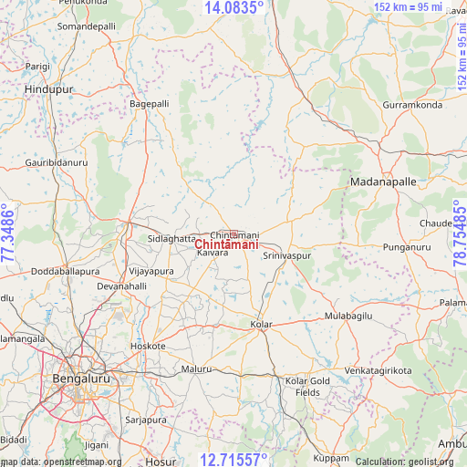
Chintāmani GPS coordinates[2]
13° 24' 1.836" North, 78° 3' 6.192" East
| Map corner | latitude | longitude |
|---|---|---|
| Upper-left | 14.0835°, | 77.3486° |
| Center: | 13.40051°, | 78.05172° |
| Lower-right: | 12.71557°, | 78.75485° |
| Map W x H: | 152.1×152.1 km | = 94.5×94.5mi |
| max Lat: | 34.9274° ⇑84.6% North |
| Chintāmani: | 13.40051° |
| min Lat: | ⇓15.4% South 8.09008° |
| min Long | Chintāmani | max Long |
| 68.82655° | 78.05172° | 96.81° |
| W 49.1%⇐ | ⇒50.9% E |
Elevation
Elevation of Chintāmani is 890 m = 2920 ft, and this is 594.4 m = 1950 ft above average elevation for this country.
| Max E: |
3681 m = 12077 ft | 4.8% |
| Chintāmani | 890 m 2920 ft | |
| Avg. | 295.6 m = 970 ft | |
Min E: |
1 m = 3 ft | 95.2% |
See also: Chintāmani elevation on elevation.city.
Geographical zone
Chintāmani is located in North Torrid zone (between Equator and Tropic of Cancer). Distance of this Northern Tropic circle is 1115.9 km =693.4 mi to North.| Distance of | km | miles | from Chintāmani |
|---|---|---|---|
| North Pole | 8517.1 | 5292.3 | to North |
| Arctic Circle | 5911.2 | 3673 | to North |
| Tropic Cancer | 1115.9 | 693.4 | to North |
| Equator | 1490 | 925.8 | to South |


Nearby cities:
15 places around Chintāmani: (largest is in red/bold)
• Bangarapet
47.5 km =29.5 mi,  163°
163°
• Bāgepalli
50.7 km =31.5 mi,  327°
327°
• Chik Ballāpur
35.2 km =21.9 mi,  276°
276°
• Dasarahalli
41.1 km =25.5 mi,  215°
215°
• Devanhalli
40.6 km =25.2 mi,  245°
245°
• Gudibanda
48.1 km =29.9 mi,  308°
308°
• Hoskote
45.8 km =28.5 mi, 216°
• Kolār
30.4 km =18.9 mi, 163°
• Madanapalle
51.5 km =32 mi,  71°
71°
• Mulbāgal
45.4 km =28.2 mi,  125°
125°
• Mālūr
45.9 km =28.5 mi,  195°
195°
• Robertsonpet
55 km =34.2 mi,  153°
153°
• Sidlaghatta
20.3 km =12.6 mi,  266°
266°
• Srīnivāspur
18.6 km =11.6 mi,  111°
111°
• Vadigenhalli
29.4 km =18.3 mi, 246°
Sources, notices
• [Note1] Compared only with cities in India existing in our database
• [Src1] Map data: © OpenStreetMap contributors (CC-BY-SA)
• [Src2] Other city data from geonames.org with taken over terms of usage.
• [Src3] Geographical zone / Annual Mean Temperature by Robert A. Rohde @ Wikipedia
