Mālūr geodata
Mālūr (Karnataka) is a populated place; located in India in Asia/Kolkata (GMT+5.5) time zone. With population of 30,677 people, there are 1413 cities with bigger population in this country. Compared to other cities in India, 86.3% of cities are located further ↑North; 51.9% of cities are located further →East and 95.5% of cities have lower elevation than Mālūr. Note1


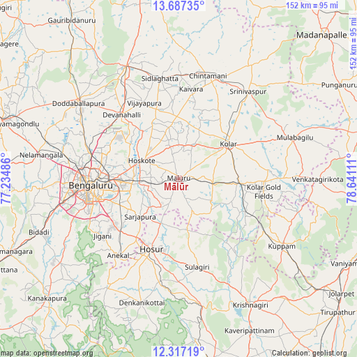
Mālūr GPS coordinates[2]
13° 0' 11.592" North, 77° 56' 16.728" East
| Map corner | latitude | longitude |
|---|---|---|
| Upper-left | 13.68735°, | 77.23486° |
| Center: | 13.00322°, | 77.93798° |
| Lower-right: | 12.31719°, | 78.64111° |
| Map W x H: | 152.3×152.4 km | = 94.6×94.7mi |
| max Lat: | 34.9274° ⇑86.3% North |
| Mālūr: | 13.00322° |
| min Lat: | ⇓13.7% South 8.09008° |
| min Long | Mālūr | max Long |
| 68.82655° | 77.93798° | 96.81° |
| W 48.1%⇐ | ⇒51.9% E |
Elevation
Elevation of Mālūr is 914 m = 2999 ft, and this is 618.4 m = 2029 ft above average elevation for this country.
| Max E: |
3681 m = 12077 ft | 4.5% |
| Mālūr | 914 m 2999 ft | |
| Avg. | 295.6 m = 970 ft | |
Min E: |
1 m = 3 ft | 95.5% |
See also: India elevation on elevation.city.
Geographical zone
Mālūr is located in North Torrid zone (between Equator and Tropic of Cancer). Distance of this Northern Tropic circle is 1160.1 km =720.9 mi to North.| Distance of | km | miles | from Mālūr |
|---|---|---|---|
| North Pole | 8561.2 | 5319.7 | to North |
| Arctic Circle | 5955.4 | 3700.5 | to North |
| Tropic Cancer | 1160.1 | 720.9 | to North |
| Equator | 1445.8 | 898.4 | to South |


Nearby cities:
15 places around Mālūr: (largest is in red/bold)
• Anekal
41.8 km =26 mi,  218°
218°
• Bangarapet
26 km =16.2 mi,  92°
92°
• Bengaluru
37.5 km =23.3 mi,  264°
264°
• Chintāmani
45.9 km =28.5 mi,  15°
15°
• Dasarahalli
15.7 km =9.8 mi,  312°
312°
• Devanhalli
36.5 km =22.7 mi,  317°
317°
• Hoskote
16.9 km =10.5 mi,  296°
296°
• Hosūr
31.8 km =19.8 mi,  201°
201°
• Kelamangalam
45.5 km =28.3 mi,  191°
191°
• Kolār
25.6 km =15.9 mi,  54°
54°
• Robertsonpet
36.9 km =22.9 mi,  98°
98°
• Sidlaghatta
43.6 km =27.1 mi,  349°
349°
• Srīnivāspur
47.7 km =29.6 mi,  38°
38°
• Vadigenhalli
35.9 km =22.3 mi,  335°
335°
• Yelahanka
38.6 km =24 mi,  286°
286°
Sources, notices
• [Note1] Compared only with cities in India existing in our database
• [Src1] Map data: © OpenStreetMap contributors (CC-BY-SA)
• [Src2] Other city data from geonames.org with taken over terms of usage.
• [Src3] Geographical zone / Annual Mean Temperature by Robert A. Rohde @ Wikipedia
