Sidhpura geodata
Sidhpura (Uttar Pradesh) is a populated place; located in India in Asia/Kolkata (GMT+5.5) time zone. With population of 14,815 people, there are 2482 cities with bigger population in this country. Compared to other cities in India, 82.7% of cities are located further ↓South; 57.8% of cities are located further ←West and 56.2% of cities have higher elevation than Sidhpura. Note1


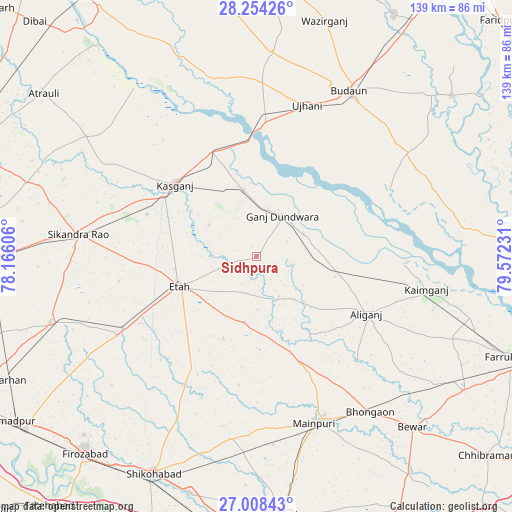
Sidhpura GPS coordinates[2]
27° 37' 59.232" North, 78° 52' 9.048" East
| Map corner | latitude | longitude |
|---|---|---|
| Upper-left | 28.25426°, | 78.16606° |
| Center: | 27.63312°, | 78.86918° |
| Lower-right: | 27.00843°, | 79.57231° |
| Map W x H: | 138.5×138.5 km | = 86.1×86.1mi |
| max Lat: | 34.9274° ⇑17.3% North |
| Sidhpura: | 27.63312° |
| min Lat: | ⇓82.7% South 8.09008° |
| min Long | Sidhpura | max Long |
| 68.82655° | 78.86918° | 96.81° |
| W 57.8%⇐ | ⇒42.2% E |
Elevation
Elevation of Sidhpura is 169 m = 554 ft, and this is 126.6 m = 415 ft below average elevation for this country.
| Max E: |
3681 m = 12077 ft | 56.2% |
| Avg. | 295.6 m = 970 ft | |
| Sidhpura | 169 m = 554 ft | |
Min E: |
1 m = 3 ft | 43.8% |
See also: India elevation on elevation.city.
Geographical zone
Sidhpura is located in North temperate zone (between Tropic of Cancer and the Arctic Circle). Distance of this Northern Tropic circle is 466.6 km =289.9 mi to South.| Distance of | km | miles | from Sidhpura |
|---|---|---|---|
| North Pole | 6934.5 | 4308.9 | to North |
| Arctic Circle | 4328.7 | 2689.7 | to North |
| Tropic Cancer | 466.6 | 289.9 | to South |
| Equator | 3072.5 | 1909.2 | to South |


Nearby cities:
15 places around Sidhpura: (largest is in red/bold)
• Alīganj
33.6 km =20.9 mi,  117°
117°
• Amānpur
15.6 km =9.7 mi,  304°
304°
• Ganj Dundwāra
13.2 km =8.2 mi,  32°
32°
• Kaimganj
46.8 km =29.1 mi,  100°
100°
• Kakrāla
43.1 km =26.8 mi,  47°
47°
• Kampil
40.2 km =25 mi,  93°
93°
• Kāsganj
29.4 km =18.3 mi,  311°
311°
• Mainpuri
47.7 km =29.6 mi,  160°
160°
• Mārahra
31.7 km =19.7 mi,  291°
291°
• Patiāli
14.2 km =8.8 mi,  63°
63°
• Sahāwar
18.4 km =11.4 mi,  349°
349°
• Sakīt
23.8 km =14.8 mi,  201°
201°
• Soron
31.1 km =19.3 mi,  337°
337°
• Ujhāni
43.4 km =27 mi,  18°
18°
• Usehat
40.6 km =25.2 mi, 63°
Sources, notices
• [Note1] Compared only with cities in India existing in our database
• [Src1] Map data: © OpenStreetMap contributors (CC-BY-SA)
• [Src2] Other city data from geonames.org with taken over terms of usage.
• [Src3] Geographical zone / Annual Mean Temperature by Robert A. Rohde @ Wikipedia
