Mārahra geodata
Mārahra (Uttar Pradesh) is a populated place; located in India in Asia/Kolkata (GMT+5.5) time zone. With population of 18,873 people, there are 2137 cities with bigger population in this country. Compared to other cities in India, 83.3% of cities are located further ↓South; 54.8% of cities are located further ←West and 53.8% of cities have higher elevation than Mārahra. Note1


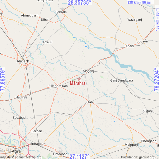
Mārahra GPS coordinates[2]
27° 44' 12.48" North, 78° 34' 8.076" East
| Map corner | latitude | longitude |
|---|---|---|
| Upper-left | 28.35735°, | 77.86579° |
| Center: | 27.7368°, | 78.56891° |
| Lower-right: | 27.1127°, | 79.27204° |
| Map W x H: | 138.4×138.4 km | = 86×86mi |
| max Lat: | 34.9274° ⇑16.7% North |
| Mārahra: | 27.7368° |
| min Lat: | ⇓83.3% South 8.09008° |
| min Long | Mārahra | max Long |
| 68.82655° | 78.56891° | 96.81° |
| W 54.8%⇐ | ⇒45.2% E |
Elevation
Elevation of Mārahra is 181 m = 594 ft, and this is 114.6 m = 376 ft below average elevation for this country.
| Max E: |
3681 m = 12077 ft | 53.8% |
| Avg. | 295.6 m = 970 ft | |
| Mārahra | 181 m = 594 ft | |
Min E: |
1 m = 3 ft | 46.2% |
See also: India elevation on elevation.city.
Geographical zone
Mārahra is located in North temperate zone (between Tropic of Cancer and the Arctic Circle). Distance of this Northern Tropic circle is 478.1 km =297.1 mi to South.| Distance of | km | miles | from Mārahra |
|---|---|---|---|
| North Pole | 6923 | 4301.8 | to North |
| Arctic Circle | 4317.1 | 2682.5 | to North |
| Tropic Cancer | 478.1 | 297.1 | to South |
| Equator | 3084 | 1916.3 | to South |


Nearby cities:
15 places around Mārahra: (largest is in red/bold)
• Amānpur
16.9 km =10.5 mi,  99°
99°
• Atraulī
42.8 km =26.6 mi,  319°
319°
• Chharra
26.6 km =16.5 mi, 321°
• Ganj Dundwāra
36.6 km =22.7 mi,  90°
90°
• Harduāganj
46.5 km =28.9 mi,  299°
299°
• Jalesar
39.3 km =24.4 mi,  221°
221°
• Jalālī
34.3 km =21.3 mi,  294°
294°
• Kāsganj
11 km =6.8 mi,  43°
43°
• Patiāli
42.6 km =26.5 mi, 96°
• Sahaswān
41.4 km =25.7 mi,  25°
25°
• Sahāwar
26.9 km =16.7 mi,  75°
75°
• Sakīt
39.5 km =24.5 mi,  148°
148°
• Sidhpura
31.7 km =19.7 mi,  111°
111°
• Sikandra Rao
19.4 km =12.1 mi,  253°
253°
• Soron
24.4 km =15.2 mi,  45°
45°
Sources, notices
• [Note1] Compared only with cities in India existing in our database
• [Src1] Map data: © OpenStreetMap contributors (CC-BY-SA)
• [Src2] Other city data from geonames.org with taken over terms of usage.
• [Src3] Geographical zone / Annual Mean Temperature by Robert A. Rohde @ Wikipedia
