Siddipet geodata
Siddipet (Telangana) is a seat of a second-order administrative division; located in India in Asia/Kolkata (GMT+5.5) time zone. With population of 64,562 people, there are 681 cities with bigger population in this country. Compared to other cities in India, 71.6% of cities are located further ↑North; 57.6% of cities are located further ←West and 82% of cities have lower elevation than Siddipet. Note1


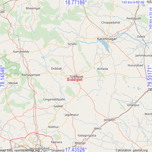
Siddipet GPS coordinates[2]
18° 6' 17.388" North, 78° 50' 54.888" East
| Map corner | latitude | longitude |
|---|---|---|
| Upper-left | 18.77186°, | 78.14546° |
| Center: | 18.10483°, | 78.84858° |
| Lower-right: | 17.43526°, | 79.55171° |
| Map W x H: | 148.6×148.6 km | = 92.3×92.3mi |
| max Lat: | 34.9274° ⇑71.6% North |
| Siddipet: | 18.10483° |
| min Lat: | ⇓28.4% South 8.09008° |
| min Long | Siddipet | max Long |
| 68.82655° | 78.84858° | 96.81° |
| W 57.6%⇐ | ⇒42.4% E |
Elevation
Elevation of Siddipet is 493 m = 1617 ft, and this is 197.4 m = 648 ft above average elevation for this country.
| Max E: |
3681 m = 12077 ft | 18% |
| Siddipet | 493 m 1617 ft | |
| Avg. | 295.6 m = 970 ft | |
Min E: |
1 m = 3 ft | 82% |
See also: Siddipet elevation on elevation.city.
Geographical zone
Siddipet is located in North Torrid zone (between Equator and Tropic of Cancer). Distance of this Northern Tropic circle is 592.9 km =368.4 mi to North.| Distance of | km | miles | from Siddipet |
|---|---|---|---|
| North Pole | 7994 | 4967.2 | to North |
| Arctic Circle | 5388.1 | 3348 | to North |
| Tropic Cancer | 592.9 | 368.4 | to North |
| Equator | 2013.1 | 1250.9 | to South |


Nearby cities:
15 places around Siddipet: (largest is in red/bold)
• Bhongīr
65.7 km =40.8 mi,  176°
176°
• Ghatkesar
74.8 km =46.5 mi,  193°
193°
• Gūdūr
68.2 km =42.4 mi, 182°
• Jagtiāl
77 km =47.8 mi,  5°
5°
• Jangaon
53 km =32.9 mi,  142°
142°
• Karīmnagar
47.5 km =29.5 mi,  38°
38°
• Kottapalli
50.6 km =31.4 mi,  30°
30°
• Kāmāreddi
58.6 km =36.4 mi,  294°
294°
• Medak
62.5 km =38.8 mi,  263°
263°
• Medchal
65.6 km =40.8 mi,  216°
216°
• Nārsingi
45.3 km =28.1 mi, 261°
• Secunderabad
74.2 km =46.1 mi,  205°
205°
• Sirsilla
31.8 km =19.8 mi,  352°
352°
• Vemalwāda
40.1 km =24.9 mi,  3°
3°
• Warangal
78.5 km =48.8 mi,  98°
98°
Sources, notices
• [Note1] Compared only with cities in India existing in our database
• [Src1] Map data: © OpenStreetMap contributors (CC-BY-SA)
• [Src2] Other city data from geonames.org with taken over terms of usage.
• [Src3] Geographical zone / Annual Mean Temperature by Robert A. Rohde @ Wikipedia
