Kāmāreddi geodata
Kāmāreddi (Telangana) is a seat of a second-order administrative division; located in India in Asia/Kolkata (GMT+5.5) time zone. With population of 71,042 people, there are 613 cities with bigger population in this country. Compared to other cities in India, 71% of cities are located further ↑North; 52.6% of cities are located further ←West and 83.8% of cities have lower elevation than Kāmāreddi. Note1


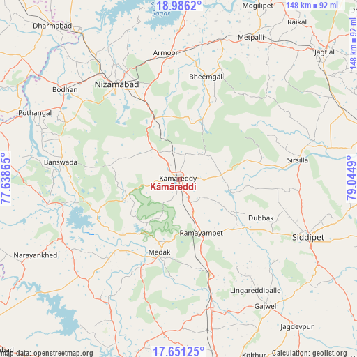
Kāmāreddi GPS coordinates[2]
18° 19' 12.036" North, 78° 20' 30.372" East
| Map corner | latitude | longitude |
|---|---|---|
| Upper-left | 18.9862°, | 77.63865° |
| Center: | 18.32001°, | 78.34177° |
| Lower-right: | 17.65125°, | 79.0449° |
| Map W x H: | 148.4×148.4 km | = 92.2×92.2mi |
| max Lat: | 34.9274° ⇑71% North |
| Kāmāreddi: | 18.32001° |
| min Lat: | ⇓29% South 8.09008° |
| min Long | Kāmāreddi | max Long |
| 68.82655° | 78.34177° | 96.81° |
| W 52.6%⇐ | ⇒47.4% E |
Elevation
Elevation of Kāmāreddi is 523 m = 1716 ft, and this is 227.4 m = 746 ft above average elevation for this country.
| Max E: |
3681 m = 12077 ft | 16.2% |
| Kāmāreddi | 523 m 1716 ft | |
| Avg. | 295.6 m = 970 ft | |
Min E: |
1 m = 3 ft | 83.8% |
See also: Kāmāreddi elevation on elevation.city.
Geographical zone
Kāmāreddi is located in North Torrid zone (between Equator and Tropic of Cancer). Distance of this Northern Tropic circle is 568.9 km =353.5 mi to North.| Distance of | km | miles | from Kāmāreddi |
|---|---|---|---|
| North Pole | 7970.1 | 4952.4 | to North |
| Arctic Circle | 5364.2 | 3333.2 | to North |
| Tropic Cancer | 568.9 | 353.5 | to North |
| Equator | 2037 | 1265.7 | to South |


Nearby cities:
15 places around Kāmāreddi: (largest is in red/bold)
• Andol
62.8 km =39 mi,  206°
206°
• Bodhan
61.3 km =38.1 mi,  308°
308°
• Bānswāda
49.1 km =30.5 mi,  277°
277°
• Chandūr
55.7 km =34.6 mi, 207°
• Jagtiāl
80.4 km =50 mi,  48°
48°
• Kondalwādi
81 km =50.3 mi, 311°
• Koratla
68.1 km =42.3 mi,  34°
34°
• Kottapalli
81.8 km =50.8 mi,  76°
76°
• Medak
31.7 km =19.7 mi,  195°
195°
• Medchal
78.2 km =48.6 mi,  169°
169°
• Nizāmābād
46.7 km =29 mi,  326°
326°
• Nārsingi
31.9 km =19.8 mi,  163°
163°
• Siddipet
58.6 km =36.4 mi,  114°
114°
• Sirsilla
50 km =31.1 mi, 81°
• Vemalwāda
57.9 km =36 mi,  73°
73°
Sources, notices
• [Note1] Compared only with cities in India existing in our database
• [Src1] Map data: © OpenStreetMap contributors (CC-BY-SA)
• [Src2] Other city data from geonames.org with taken over terms of usage.
• [Src3] Geographical zone / Annual Mean Temperature by Robert A. Rohde @ Wikipedia
