Vemalwāda geodata
Vemalwāda (Telangana) is a populated place; located in India in Asia/Kolkata (GMT+5.5) time zone. With population of 22,920 people, there are 1839 cities with bigger population in this country. Compared to other cities in India, 70.4% of cities are located further ↑North; 57.7% of cities are located further ←West and 71.2% of cities have lower elevation than Vemalwāda. Note1


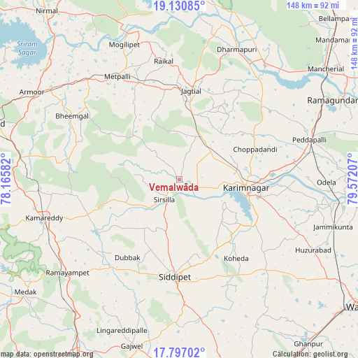
Vemalwāda GPS coordinates[2]
18° 27' 54.828" North, 78° 52' 8.184" East
| Map corner | latitude | longitude |
|---|---|---|
| Upper-left | 19.13085°, | 78.16582° |
| Center: | 18.46523°, | 78.86894° |
| Lower-right: | 17.79702°, | 79.57207° |
| Map W x H: | 148.3×148.3 km | = 92.1×92.1mi |
| max Lat: | 34.9274° ⇑70.4% North |
| Vemalwāda: | 18.46523° |
| min Lat: | ⇓29.6% South 8.09008° |
| min Long | Vemalwāda | max Long |
| 68.82655° | 78.86894° | 96.81° |
| W 57.7%⇐ | ⇒42.3% E |
Elevation
Elevation of Vemalwāda is 338 m = 1109 ft, and this is 42.4 m = 139 ft above average elevation for this country.
| Max E: |
3681 m = 12077 ft | 28.8% |
| Vemalwāda | 338 m 1109 ft | |
| Avg. | 295.6 m = 970 ft | |
Min E: |
1 m = 3 ft | 71.2% |
See also: India elevation on elevation.city.
Geographical zone
Vemalwāda is located in North Torrid zone (between Equator and Tropic of Cancer). Distance of this Northern Tropic circle is 552.8 km =343.5 mi to North.| Distance of | km | miles | from Vemalwāda |
|---|---|---|---|
| North Pole | 7953.9 | 4942.3 | to North |
| Arctic Circle | 5348 | 3323.1 | to North |
| Tropic Cancer | 552.8 | 343.5 | to North |
| Equator | 2053.1 | 1275.7 | to South |


Nearby cities:
15 places around Vemalwāda: (largest is in red/bold)
• Jagtiāl
37 km =23 mi,  7°
7°
• Karīmnagar
27.5 km =17.1 mi,  96°
96°
• Koratla
42.9 km =26.7 mi,  337°
337°
• Kottapalli
24 km =14.9 mi,  81°
81°
• Kāmāreddi
57.9 km =36 mi,  253°
253°
• Lakshettipet
57.7 km =35.9 mi,  39°
39°
• Mancherāl
74.2 km =46.1 mi,  52°
52°
• Medak
79.4 km =49.3 mi,  233°
233°
• Nārsingi
66.2 km =41.1 mi, 225°
• Nāspur
75.4 km =46.9 mi,  55°
55°
• Peddapalli
55.8 km =34.7 mi,  72°
72°
• Ramagundam
71.4 km =44.4 mi, 63°
• Rāmgundam
71.9 km =44.7 mi, 58°
• Siddipet
40.1 km =24.9 mi,  183°
183°
• Sirsilla
10.5 km =6.5 mi,  215°
215°
Sources, notices
• [Note1] Compared only with cities in India existing in our database
• [Src1] Map data: © OpenStreetMap contributors (CC-BY-SA)
• [Src2] Other city data from geonames.org with taken over terms of usage.
• [Src3] Geographical zone / Annual Mean Temperature by Robert A. Rohde @ Wikipedia
