Maddūr geodata
Maddūr (Karnataka) is a populated place; located in India in Asia/Kolkata (GMT+5.5) time zone. With population of 28,141 people, there are 1534 cities with bigger population in this country. Compared to other cities in India, 88.2% of cities are located further ↑North; 62.6% of cities are located further →East and 90.3% of cities have lower elevation than Maddūr. Note1


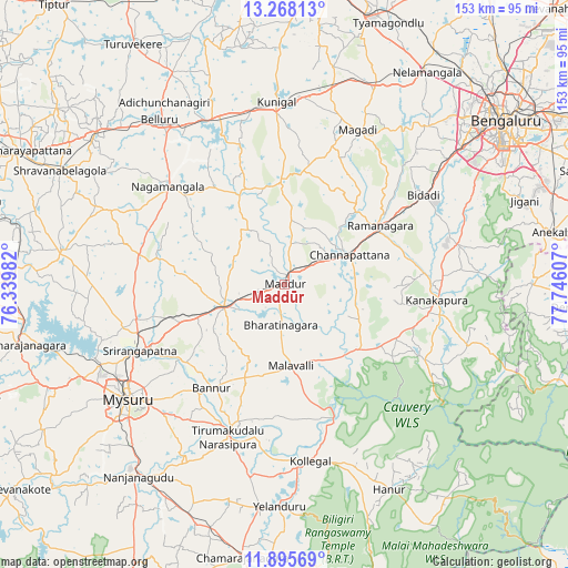
Maddūr GPS coordinates[2]
12° 34' 58.188" North, 77° 2' 34.584" East
| Map corner | latitude | longitude |
|---|---|---|
| Upper-left | 13.26813°, | 76.33982° |
| Center: | 12.58283°, | 77.04294° |
| Lower-right: | 11.89569°, | 77.74607° |
| Map W x H: | 152.6×152.6 km | = 94.8×94.8mi |
| max Lat: | 34.9274° ⇑88.2% North |
| Maddūr: | 12.58283° |
| min Lat: | ⇓11.8% South 8.09008° |
| min Long | Maddūr | max Long |
| 68.82655° | 77.04294° | 96.81° |
| W 37.4%⇐ | ⇒62.6% E |
Elevation
Elevation of Maddūr is 643 m = 2110 ft, and this is 347.4 m = 1140 ft above average elevation for this country.
| Max E: |
3681 m = 12077 ft | 9.7% |
| Maddūr | 643 m 2110 ft | |
| Avg. | 295.6 m = 970 ft | |
Min E: |
1 m = 3 ft | 90.3% |
See also: India elevation on elevation.city.
Geographical zone
Maddūr is located in North Torrid zone (between Equator and Tropic of Cancer). Distance of this Northern Tropic circle is 1206.8 km =749.9 mi to North.| Distance of | km | miles | from Maddūr |
|---|---|---|---|
| North Pole | 8608 | 5348.8 | to North |
| Arctic Circle | 6002.1 | 3729.5 | to North |
| Tropic Cancer | 1206.8 | 749.9 | to North |
| Equator | 1399.1 | 869.4 | to South |


Nearby cities:
15 places around Maddūr: (largest is in red/bold)
• Bannūr
34 km =21.1 mi,  215°
215°
• Channapatna
19.3 km =12 mi,  66°
66°
• Closepet
30.1 km =18.7 mi,  59°
59°
• French Rocks
41 km =25.5 mi,  257°
257°
• Kollegāl
48.2 km =30 mi,  171°
171°
• Kunigal
49 km =30.4 mi,  357°
357°
• Kānkānhalli
41.1 km =25.5 mi,  95°
95°
• Malavalli
22 km =13.7 mi,  175°
175°
• Mandya
17.2 km =10.7 mi,  246°
246°
• Melukote
43.7 km =27.2 mi,  281°
281°
• Mysore
54.1 km =33.6 mi,  234°
234°
• Māgadi
46 km =28.6 mi,  25°
25°
• Nāgamangala
40.9 km =25.4 mi,  310°
310°
• Shrīrangapattana
42.8 km =26.6 mi, 245°
• Tirumakūdal Narsipur
44 km =27.3 mi,  200°
200°
Sources, notices
• [Note1] Compared only with cities in India existing in our database
• [Src1] Map data: © OpenStreetMap contributors (CC-BY-SA)
• [Src2] Other city data from geonames.org with taken over terms of usage.
• [Src3] Geographical zone / Annual Mean Temperature by Robert A. Rohde @ Wikipedia
