French Rocks geodata
French Rocks (Karnataka) is a populated place; located in India in Asia/Kolkata (GMT+5.5) time zone. With population of 19,051 people, there are 2118 cities with bigger population in this country. Compared to other cities in India, 88.5% of cities are located further ↑North; 66.6% of cities are located further →East and 92.8% of cities have lower elevation than French Rocks. Note1


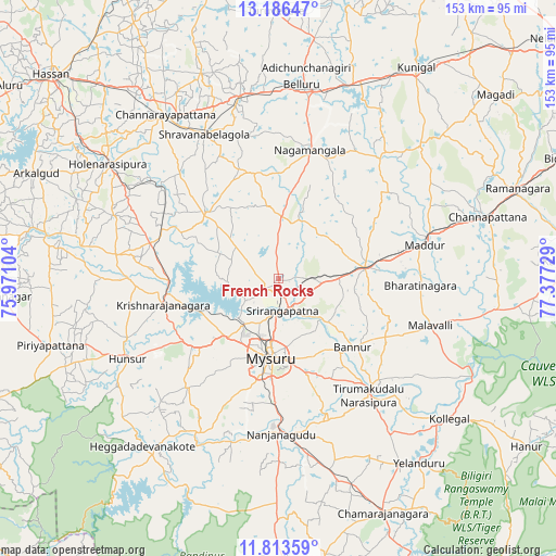
French Rocks GPS coordinates[2]
12° 30' 3.384" North, 76° 40' 26.976" East
| Map corner | latitude | longitude |
|---|---|---|
| Upper-left | 13.18647°, | 75.97104° |
| Center: | 12.50094°, | 76.67416° |
| Lower-right: | 11.81359°, | 77.37729° |
| Map W x H: | 152.6×152.7 km | = 94.8×94.9mi |
| max Lat: | 34.9274° ⇑88.5% North |
| French Rocks: | 12.50094° |
| min Lat: | ⇓11.5% South 8.09008° |
| min Long | French Rocks | max Long |
| 68.82655° | 76.67416° | 96.81° |
| W 33.4%⇐ | ⇒66.6% E |
Elevation
Elevation of French Rocks is 734 m = 2408 ft, and this is 438.4 m = 1438 ft above average elevation for this country.
| Max E: |
3681 m = 12077 ft | 7.2% |
| French Rocks | 734 m 2408 ft | |
| Avg. | 295.6 m = 970 ft | |
Min E: |
1 m = 3 ft | 92.8% |
See also: India elevation on elevation.city.
Geographical zone
French Rocks is located in North Torrid zone (between Equator and Tropic of Cancer). Distance of this Northern Tropic circle is 1215.9 km =755.5 mi to North.| Distance of | km | miles | from French Rocks |
|---|---|---|---|
| North Pole | 8617.1 | 5354.4 | to North |
| Arctic Circle | 6011.2 | 3735.2 | to North |
| Tropic Cancer | 1215.9 | 755.5 | to North |
| Equator | 1390 | 863.7 | to South |


Nearby cities:
15 places around French Rocks: (largest is in red/bold)
• Bannūr
27.7 km =17.2 mi,  132°
132°
• Bellūru
53.8 km =33.4 mi,  6°
6°
• Channarāyapatna
54.8 km =34.1 mi,  325°
325°
• Hunsūr
46.9 km =29.1 mi,  242°
242°
• Krishnarājpet
27.3 km =17 mi,  312°
312°
• Maddūr
41 km =25.5 mi,  77°
77°
• Malavalli
43.9 km =27.3 mi,  107°
107°
• Mandya
24.4 km =15.2 mi, 84°
• Melukote
18.2 km =11.3 mi,  351°
351°
• Mysore
22.9 km =14.2 mi,  189°
189°
• Nanjangūd
42.6 km =26.5 mi,  178°
178°
• Nāgamangala
36.5 km =22.7 mi, 13°
• Shrīrangapattana
8.8 km =5.5 mi,  172°
172°
• Srāvana Belgola
44.4 km =27.6 mi, 333°
• Tirumakūdal Narsipur
40.5 km =25.2 mi,  142°
142°
Sources, notices
• [Note1] Compared only with cities in India existing in our database
• [Src1] Map data: © OpenStreetMap contributors (CC-BY-SA)
• [Src2] Other city data from geonames.org with taken over terms of usage.
• [Src3] Geographical zone / Annual Mean Temperature by Robert A. Rohde @ Wikipedia
