Mandya geodata
Mandya (Karnataka) is a populated place; located in India in Asia/Kolkata (GMT+5.5) time zone. With population of 134,845 people, there are 322 cities with bigger population in this country. Compared to other cities in India, 88.4% of cities are located further ↑North; 64.4% of cities are located further →East and 91.9% of cities have lower elevation than Mandya. Note1


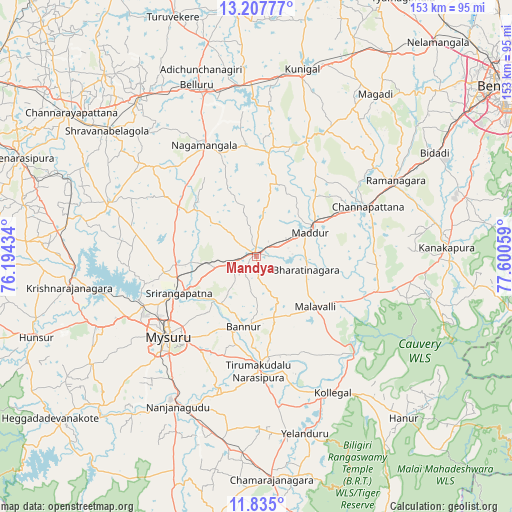
Mandya GPS coordinates[2]
12° 31' 20.28" North, 76° 53' 50.856" East
| Map corner | latitude | longitude |
|---|---|---|
| Upper-left | 13.20777°, | 76.19434° |
| Center: | 12.5223°, | 76.89746° |
| Lower-right: | 11.835°, | 77.60059° |
| Map W x H: | 152.6×152.6 km | = 94.8×94.8mi |
| max Lat: | 34.9274° ⇑88.4% North |
| Mandya: | 12.5223° |
| min Lat: | ⇓11.6% South 8.09008° |
| min Long | Mandya | max Long |
| 68.82655° | 76.89746° | 96.81° |
| W 35.6%⇐ | ⇒64.4% E |
Elevation
Elevation of Mandya is 681 m = 2234 ft, and this is 385.4 m = 1264 ft above average elevation for this country.
| Max E: |
3681 m = 12077 ft | 8.1% |
| Mandya | 681 m 2234 ft | |
| Avg. | 295.6 m = 970 ft | |
Min E: |
1 m = 3 ft | 91.9% |
See also: Mandya elevation on elevation.city.
Geographical zone
Mandya is located in North Torrid zone (between Equator and Tropic of Cancer). Distance of this Northern Tropic circle is 1213.6 km =754.1 mi to North.| Distance of | km | miles | from Mandya |
|---|---|---|---|
| North Pole | 8614.7 | 5352.9 | to North |
| Arctic Circle | 6008.8 | 3733.7 | to North |
| Tropic Cancer | 1213.6 | 754.1 | to North |
| Equator | 1392.3 | 865.1 | to South |


Nearby cities:
15 places around Mandya: (largest is in red/bold)
• Bannūr
21.4 km =13.3 mi,  190°
190°
• Bellūru
54.1 km =33.6 mi,  340°
340°
• Channapatna
36.5 km =22.7 mi,  66°
66°
• Closepet
47.2 km =29.3 mi,  61°
61°
• French Rocks
24.4 km =15.2 mi,  264°
264°
• Kollegāl
47 km =29.2 mi,  150°
150°
• Krishnarājpet
47.3 km =29.4 mi,  289°
289°
• Maddūr
17.2 km =10.7 mi, 66°
• Malavalli
23.3 km =14.5 mi,  130°
130°
• Melukote
31.2 km =19.4 mi,  300°
300°
• Mysore
37.5 km =23.3 mi,  228°
228°
• Nanjangūd
50.6 km =31.4 mi,  207°
207°
• Nāgamangala
36.5 km =22.7 mi,  334°
334°
• Shrīrangapattana
25.6 km =15.9 mi,  244°
244°
• Tirumakūdal Narsipur
34.5 km =21.4 mi,  179°
179°
Sources, notices
• [Note1] Compared only with cities in India existing in our database
• [Src1] Map data: © OpenStreetMap contributors (CC-BY-SA)
• [Src2] Other city data from geonames.org with taken over terms of usage.
• [Src3] Geographical zone / Annual Mean Temperature by Robert A. Rohde @ Wikipedia
