Melukote geodata
Melukote (Karnataka) is a populated place; located in India in Asia/Kolkata (GMT+5.5) time zone. With population of 4,011 people, there are 3379 cities with bigger population in this country. Compared to other cities in India, 88% of cities are located further ↑North; 66.8% of cities are located further →East and 96.3% of cities have lower elevation than Melukote. Note1


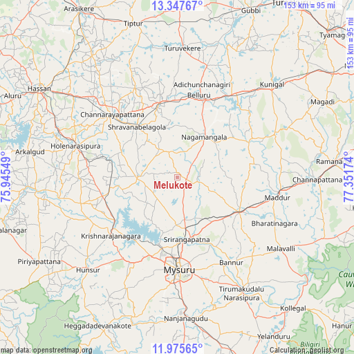
Melukote GPS coordinates[2]
12° 39' 45.288" North, 76° 38' 54.996" East
| Map corner | latitude | longitude |
|---|---|---|
| Upper-left | 13.34767°, | 75.94549° |
| Center: | 12.66258°, | 76.64861° |
| Lower-right: | 11.97565°, | 77.35174° |
| Map W x H: | 152.6×152.6 km | = 94.8×94.8mi |
| max Lat: | 34.9274° ⇑88% North |
| Melukote: | 12.66258° |
| min Lat: | ⇓12% South 8.09008° |
| min Long | Melukote | max Long |
| 68.82655° | 76.64861° | 96.81° |
| W 33.2%⇐ | ⇒66.8% E |
Elevation
Elevation of Melukote is 1018 m = 3340 ft, and this is 722.4 m = 2370 ft above average elevation for this country.
| Max E: |
3681 m = 12077 ft | 3.7% |
| Melukote | 1018 m 3340 ft | |
| Avg. | 295.6 m = 970 ft | |
Min E: |
1 m = 3 ft | 96.3% |
See also: India elevation on elevation.city.
Geographical zone
Melukote is located in North Torrid zone (between Equator and Tropic of Cancer). Distance of this Northern Tropic circle is 1198 km =744.4 mi to North.| Distance of | km | miles | from Melukote |
|---|---|---|---|
| North Pole | 8599.1 | 5343.2 | to North |
| Arctic Circle | 5993.2 | 3724 | to North |
| Tropic Cancer | 1198 | 744.4 | to North |
| Equator | 1407.9 | 874.8 | to South |


Nearby cities:
15 places around Melukote: (largest is in red/bold)
• Bannūr
43.4 km =27 mi,  147°
147°
• Bellūru
36.6 km =22.7 mi,  14°
14°
• Channarāyapatna
39.2 km =24.4 mi,  313°
313°
• French Rocks
18.2 km =11.3 mi,  171°
171°
• Hole Narsipur
46.1 km =28.6 mi,  287°
287°
• Hunsūr
55.5 km =34.5 mi,  224°
224°
• Krishnarājpet
17.5 km =10.9 mi,  271°
271°
• Maddūr
43.7 km =27.2 mi,  101°
101°
• Malavalli
54.3 km =33.7 mi,  124°
124°
• Mandya
31.2 km =19.4 mi, 120°
• Mysore
40.6 km =25.2 mi,  181°
181°
• Nāgamangala
20.9 km =13 mi,  33°
33°
• Shrīrangapattana
27 km =16.8 mi, 171°
• Srāvana Belgola
27.7 km =17.2 mi,  321°
321°
• Turuvekere
55.8 km =34.7 mi,  1°
1°
Sources, notices
• [Note1] Compared only with cities in India existing in our database
• [Src1] Map data: © OpenStreetMap contributors (CC-BY-SA)
• [Src2] Other city data from geonames.org with taken over terms of usage.
• [Src3] Geographical zone / Annual Mean Temperature by Robert A. Rohde @ Wikipedia
