Nongstoin geodata
Nongstoin (Meghalaya) is a populated place; located in India in Asia/Kolkata (GMT+5.5) time zone. With population of 25,758 people, there are 1651 cities with bigger population in this country. Compared to other cities in India, 67% of cities are located further ↓South; 96.2% of cities are located further ←West and 97.2% of cities have lower elevation than Nongstoin. Note1


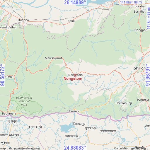
Nongstoin GPS coordinates[2]
25° 31' 1.344" North, 91° 15' 53.424" East
| Map corner | latitude | longitude |
|---|---|---|
| Upper-left | 26.14989°, | 90.56172° |
| Center: | 25.51704°, | 91.26484° |
| Lower-right: | 24.88083°, | 91.96797° |
| Map W x H: | 141.1×141.1 km | = 87.7×87.7mi |
| max Lat: | 34.9274° ⇑33% North |
| Nongstoin: | 25.51704° |
| min Lat: | ⇓67% South 8.09008° |
| min Long | Nongstoin | max Long |
| 68.82655° | 91.26484° | 96.81° |
| W 96.2%⇐ | ⇒3.8% E |
Elevation
Elevation of Nongstoin is 1321 m = 4334 ft, and this is 1025.4 m = 3364 ft above average elevation for this country.
| Max E: |
3681 m = 12077 ft | 2.8% |
| Nongstoin | 1321 m 4334 ft | |
| Avg. | 295.6 m = 970 ft | |
Min E: |
1 m = 3 ft | 97.2% |
See also: India elevation on elevation.city.
Geographical zone
Nongstoin is located in North temperate zone (between Tropic of Cancer and the Arctic Circle). Distance of this Northern Tropic circle is 231.3 km =143.7 mi to South.| Distance of | km | miles | from Nongstoin |
|---|---|---|---|
| North Pole | 7169.8 | 4455.1 | to North |
| Arctic Circle | 4563.9 | 2835.9 | to North |
| Tropic Cancer | 231.3 | 143.7 | to South |
| Equator | 2837.2 | 1763 | to South |


Nearby cities:
15 places around Nongstoin: (largest is in red/bold)
• Barpeta
93.3 km =58 mi,  343°
343°
• Cherrapunji
49.5 km =30.8 mi,  119°
119°
• Dispur
87.2 km =54.2 mi,  37°
37°
• Goālpāra
97.3 km =60.5 mi,  318°
318°
• Guwahati
88.4 km =54.9 mi,  32°
32°
• Howli
104.6 km =65 mi, 344°
• Hājo
85.1 km =52.9 mi,  17°
17°
• Mairang
37.6 km =23.4 mi,  82°
82°
• Nongpoh
74.8 km =46.5 mi,  55°
55°
• North Guwāhāti
88.3 km =54.9 mi, 31°
• Palāsbāri
72.9 km =45.3 mi, 22°
• Resubelpara
78.7 km =48.9 mi,  303°
303°
• Shillong
62.3 km =38.7 mi, 84°
• Soalkuchi
78.6 km =48.8 mi, 22°
• Williamnagar
65.1 km =40.5 mi,  267°
267°
Sources, notices
• [Note1] Compared only with cities in India existing in our database
• [Src1] Map data: © OpenStreetMap contributors (CC-BY-SA)
• [Src2] Other city data from geonames.org with taken over terms of usage.
• [Src3] Geographical zone / Annual Mean Temperature by Robert A. Rohde @ Wikipedia
