Cherrapunji geodata
Cherrapunji (Meghalaya) is a populated place; located in India in Asia/Kolkata (GMT+5.5) time zone. With population of 11,090 people, there are 2825 cities with bigger population in this country. Compared to other cities in India, 65.2% of cities are located further ↓South; 96.6% of cities are located further ←West and 97.7% of cities have lower elevation than Cherrapunji. Note1


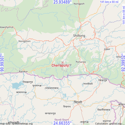
Cherrapunji GPS coordinates[2]
25° 18' 3.204" North, 91° 41' 46.284" East
| Map corner | latitude | longitude |
|---|---|---|
| Upper-left | 25.93489°, | 90.99307° |
| Center: | 25.30089°, | 91.69619° |
| Lower-right: | 24.66355°, | 92.39932° |
| Map W x H: | 141.4×141.4 km | = 87.9×87.9mi |
| max Lat: | 34.9274° ⇑34.8% North |
| Cherrapunji: | 25.30089° |
| min Lat: | ⇓65.2% South 8.09008° |
| min Long | Cherrapunji | max Long |
| 68.82655° | 91.69619° | 96.81° |
| W 96.6%⇐ | ⇒3.4% E |
Elevation
Elevation of Cherrapunji is 1505 m = 4938 ft, and this is 1209.4 m = 3968 ft above average elevation for this country.
| Max E: |
3681 m = 12077 ft | 2.3% |
| Cherrapunji | 1505 m 4938 ft | |
| Avg. | 295.6 m = 970 ft | |
Min E: |
1 m = 3 ft | 97.7% |
See also: India elevation on elevation.city.
Geographical zone
Cherrapunji is located in North temperate zone (between Tropic of Cancer and the Arctic Circle). Distance of this Northern Tropic circle is 207.3 km =128.8 mi to South.| Distance of | km | miles | from Cherrapunji |
|---|---|---|---|
| North Pole | 7193.9 | 4470.1 | to North |
| Arctic Circle | 4588 | 2850.9 | to North |
| Tropic Cancer | 207.3 | 128.8 | to South |
| Equator | 2813.2 | 1748 | to South |


Nearby cities:
15 places around Cherrapunji: (largest is in red/bold)
• Badarpur
102.6 km =63.8 mi,  117°
117°
• Dispur
93.4 km =58 mi,  6°
6°
• Guwahati
98.4 km =61.1 mi,  2°
2°
• Hailākāndi
110.9 km =68.9 mi,  128°
128°
• Hājo
106.4 km =66.1 mi,  350°
350°
• Karīmganj
81.9 km =50.9 mi, 125°
• Khliehriat
67.7 km =42.1 mi,  84°
84°
• Mairang
29.6 km =18.4 mi, 348°
• Nongpoh
69.3 km =43.1 mi,  15°
15°
• Nongstoin
49.5 km =30.8 mi,  299°
299°
• North Guwāhāti
99.7 km =62 mi, 1°
• Palāsbāri
92.8 km =57.7 mi, 350°
• Shillong
35.2 km =21.9 mi,  32°
32°
• Soalkuchi
97.2 km =60.4 mi, 352°
• Williamnagar
110.6 km =68.7 mi,  281°
281°
Sources, notices
• [Note1] Compared only with cities in India existing in our database
• [Src1] Map data: © OpenStreetMap contributors (CC-BY-SA)
• [Src2] Other city data from geonames.org with taken over terms of usage.
• [Src3] Geographical zone / Annual Mean Temperature by Robert A. Rohde @ Wikipedia
