Jānsath geodata
Jānsath (Uttar Pradesh) is a populated place; located in India in Asia/Kolkata (GMT+5.5) time zone. With population of 19,467 people, there are 2076 cities with bigger population in this country. Compared to other cities in India, 90.3% of cities are located further ↓South; 53% of cities are located further →East and 58.6% of cities have lower elevation than Jānsath. Note1


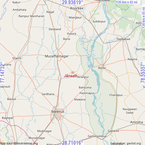
Jānsath GPS coordinates[2]
29° 19' 30.072" North, 77° 51' 1.584" East
| Map corner | latitude | longitude |
|---|---|---|
| Upper-left | 29.93619°, | 77.14732° |
| Center: | 29.32502°, | 77.85044° |
| Lower-right: | 28.71016°, | 78.55357° |
| Map W x H: | 136.3×136.3 km | = 84.7×84.7mi |
| max Lat: | 34.9274° ⇑9.7% North |
| Jānsath: | 29.32502° |
| min Lat: | ⇓90.3% South 8.09008° |
| min Long | Jānsath | max Long |
| 68.82655° | 77.85044° | 96.81° |
| W 47%⇐ | ⇒53% E |
Elevation
Elevation of Jānsath is 243 m = 797 ft, and this is 52.6 m = 173 ft below average elevation for this country.
| Max E: |
3681 m = 12077 ft | 41.4% |
| Avg. | 295.6 m = 970 ft | |
| Jānsath | 243 m = 797 ft | |
Min E: |
1 m = 3 ft | 58.6% |
See also: India elevation on elevation.city.
Geographical zone
Jānsath is located in North temperate zone (between Tropic of Cancer and the Arctic Circle). Distance of this Northern Tropic circle is 654.7 km =406.8 mi to South.| Distance of | km | miles | from Jānsath |
|---|---|---|---|
| North Pole | 6746.4 | 4192 | to North |
| Arctic Circle | 4140.5 | 2572.8 | to North |
| Tropic Cancer | 654.7 | 406.8 | to South |
| Equator | 3260.6 | 2026 | to South |


Nearby cities:
15 places around Jānsath: (largest is in red/bold)
• Bahsūma
18.2 km =11.3 mi,  139°
139°
• Bijnor
28.2 km =17.5 mi,  79°
79°
• Charthāwal
35 km =21.7 mi,  314°
314°
• Daurāla
27.5 km =17.1 mi,  211°
211°
• Hastināpur
23.8 km =14.8 mi, 140°
• Jhālu
36.4 km =22.6 mi,  88°
88°
• Khatauli
12.5 km =7.8 mi,  245°
245°
• Lāwar Khās
24.8 km =15.4 mi,  196°
196°
• Mandāwar
32.3 km =20.1 mi,  56°
56°
• Mawāna
25.7 km =16 mi,  164°
164°
• Muzaffarnagar
21.6 km =13.4 mi,  318°
318°
• Mīrānpur
10.3 km =6.4 mi,  111°
111°
• Phalauda
15.3 km =9.5 mi,  187°
187°
• Sardhana
30.4 km =18.9 mi,  228°
228°
• Shāhpur
29.1 km =18.1 mi,  275°
275°
Sources, notices
• [Note1] Compared only with cities in India existing in our database
• [Src1] Map data: © OpenStreetMap contributors (CC-BY-SA)
• [Src2] Other city data from geonames.org with taken over terms of usage.
• [Src3] Geographical zone / Annual Mean Temperature by Robert A. Rohde @ Wikipedia
