Sardhana geodata
Sardhana (Uttar Pradesh) is a populated place; located in India in Asia/Kolkata (GMT+5.5) time zone. With population of 49,857 people, there are 891 cities with bigger population in this country. Compared to other cities in India, 89.5% of cities are located further ↓South; 55.8% of cities are located further →East and 57.7% of cities have lower elevation than Sardhana. Note1


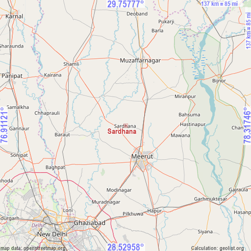
Sardhana GPS coordinates[2]
29° 8' 43.836" North, 77° 36' 51.588" East
| Map corner | latitude | longitude |
|---|---|---|
| Upper-left | 29.75777°, | 76.91121° |
| Center: | 29.14551°, | 77.61433° |
| Lower-right: | 28.52958°, | 78.31746° |
| Map W x H: | 136.6×136.6 km | = 84.9×84.9mi |
| max Lat: | 34.9274° ⇑10.5% North |
| Sardhana: | 29.14551° |
| min Lat: | ⇓89.5% South 8.09008° |
| min Long | Sardhana | max Long |
| 68.82655° | 77.61433° | 96.81° |
| W 44.2%⇐ | ⇒55.8% E |
Elevation
Elevation of Sardhana is 238 m = 781 ft, and this is 57.6 m = 189 ft below average elevation for this country.
| Max E: |
3681 m = 12077 ft | 42.3% |
| Avg. | 295.6 m = 970 ft | |
| Sardhana | 238 m = 781 ft | |
Min E: |
1 m = 3 ft | 57.7% |
See also: Sardhana elevation on elevation.city.
Geographical zone
Sardhana is located in North temperate zone (between Tropic of Cancer and the Arctic Circle). Distance of this Northern Tropic circle is 634.8 km =394.4 mi to South.| Distance of | km | miles | from Sardhana |
|---|---|---|---|
| North Pole | 6766.4 | 4204.4 | to North |
| Arctic Circle | 4160.5 | 2585.2 | to North |
| Tropic Cancer | 634.8 | 394.4 | to South |
| Equator | 3240.7 | 2013.7 | to South |


Nearby cities:
15 places around Sardhana: (largest is in red/bold)
• Bahsūma
35.3 km =21.9 mi,  79°
79°
• Baraut
34.4 km =21.4 mi,  261°
261°
• Budhāna
20.8 km =12.9 mi,  319°
319°
• Daurāla
9.5 km =5.9 mi,  112°
112°
• Jānsath
30.4 km =18.9 mi,  48°
48°
• Khatauli
18.7 km =11.6 mi,  37°
37°
• Lāwar Khās
16.3 km =10.1 mi,  103°
103°
• Mawāna
30.3 km =18.8 mi, 99°
• Meerut
20.5 km =12.7 mi,  154°
154°
• Niwāri
30.9 km =19.2 mi,  193°
193°
• Parīchhatgarh
36.2 km =22.5 mi,  120°
120°
• Phalauda
21.5 km =13.4 mi, 77°
• Shāhpur
23.5 km =14.6 mi,  345°
345°
• Sisauli
33 km =20.5 mi,  334°
334°
• Tīkri
26.9 km =16.7 mi,  290°
290°
Sources, notices
• [Note1] Compared only with cities in India existing in our database
• [Src1] Map data: © OpenStreetMap contributors (CC-BY-SA)
• [Src2] Other city data from geonames.org with taken over terms of usage.
• [Src3] Geographical zone / Annual Mean Temperature by Robert A. Rohde @ Wikipedia
