Muzaffarnagar geodata
Muzaffarnagar (Uttar Pradesh) is a seat of a second-order administrative division; located in India in Asia/Kolkata (GMT+5.5) time zone. With population of 349,706 people, there are 122 cities with bigger population in this country. Compared to other cities in India, 91% of cities are located further ↓South; 55% of cities are located further →East and 60.1% of cities have lower elevation than Muzaffarnagar. Note1


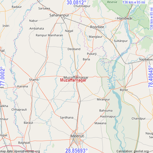
Muzaffarnagar GPS coordinates[2]
29° 28' 15.276" North, 77° 42' 11.952" East
| Map corner | latitude | longitude |
|---|---|---|
| Upper-left | 30.0812°, | 77.0002° |
| Center: | 29.47091°, | 77.70332° |
| Lower-right: | 28.85693°, | 78.40645° |
| Map W x H: | 136.1×136.1 km | = 84.6×84.6mi |
| max Lat: | 34.9274° ⇑9% North |
| Muzaffarnagar: | 29.47091° |
| min Lat: | ⇓91% South 8.09008° |
| min Long | Muzaffarnagar | max Long |
| 68.82655° | 77.70332° | 96.81° |
| W 45%⇐ | ⇒55% E |
Elevation
Elevation of Muzaffarnagar is 251 m = 823 ft, and this is 44.6 m = 146 ft below average elevation for this country.
| Max E: |
3681 m = 12077 ft | 39.9% |
| Avg. | 295.6 m = 970 ft | |
| Muzaffarnagar | 251 m = 823 ft | |
Min E: |
1 m = 3 ft | 60.1% |
See also: Muzaffarnagar elevation on elevation.city.
Geographical zone
Muzaffarnagar is located in North temperate zone (between Tropic of Cancer and the Arctic Circle). Distance of this Northern Tropic circle is 670.9 km =416.9 mi to South.| Distance of | km | miles | from Muzaffarnagar |
|---|---|---|---|
| North Pole | 6730.2 | 4182 | to North |
| Arctic Circle | 4124.3 | 2562.7 | to North |
| Tropic Cancer | 670.9 | 416.9 | to South |
| Equator | 3276.9 | 2036.2 | to South |


Nearby cities:
15 places around Muzaffarnagar: (largest is in red/bold)
• Banat
33.8 km =21 mi,  268°
268°
• Budhāna
30 km =18.6 mi,  227°
227°
• Charthāwal
13.5 km =8.4 mi,  308°
308°
• Deoband
25 km =15.5 mi,  354°
354°
• Jalālābad
30.4 km =18.9 mi,  302°
302°
• Jānsath
21.6 km =13.4 mi,  138°
138°
• Khatauli
21.6 km =13.4 mi,  172°
172°
• Mīrānpur
31.2 km =19.4 mi,  130°
130°
• Nanauta
38.5 km =23.9 mi, 314°
• Phalauda
33.7 km =20.9 mi,  158°
158°
• Sardhana
37.2 km =23.1 mi,  193°
193°
• Shāhpur
19.9 km =12.4 mi, 227°
• Shāmli
38.2 km =23.7 mi, 266°
• Sisauli
23.6 km =14.7 mi,  254°
254°
• Thāna Bhawan
30.4 km =18.9 mi,  294°
294°
Sources, notices
• [Note1] Compared only with cities in India existing in our database
• [Src1] Map data: © OpenStreetMap contributors (CC-BY-SA)
• [Src2] Other city data from geonames.org with taken over terms of usage.
• [Src3] Geographical zone / Annual Mean Temperature by Robert A. Rohde @ Wikipedia
