Shāhi geodata
Shāhi (Uttar Pradesh) is a populated place; located in India in Asia/Kolkata (GMT+5.5) time zone. With population of 16,064 people, there are 2366 cities with bigger population in this country. Compared to other cities in India, 86.9% of cities are located further ↓South; 62% of cities are located further ←West and 54% of cities have higher elevation than Shāhi. Note1


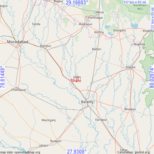
Shāhi GPS coordinates[2]
28° 33' 0.828" North, 79° 19' 3.396" East
| Map corner | latitude | longitude |
|---|---|---|
| Upper-left | 29.16603°, | 78.61449° |
| Center: | 28.55023°, | 79.31761° |
| Lower-right: | 27.9308°, | 80.02074° |
| Map W x H: | 137.3×137.3 km | = 85.3×85.3mi |
| max Lat: | 34.9274° ⇑13.1% North |
| Shāhi: | 28.55023° |
| min Lat: | ⇓86.9% South 8.09008° |
| min Long | Shāhi | max Long |
| 68.82655° | 79.31761° | 96.81° |
| W 62%⇐ | ⇒38% E |
Elevation
Elevation of Shāhi is 180 m = 591 ft, and this is 115.6 m = 379 ft below average elevation for this country.
| Max E: |
3681 m = 12077 ft | 54% |
| Avg. | 295.6 m = 970 ft | |
| Shāhi | 180 m = 591 ft | |
Min E: |
1 m = 3 ft | 46% |
See also: India elevation on elevation.city.
Geographical zone
Shāhi is located in North temperate zone (between Tropic of Cancer and the Arctic Circle). Distance of this Northern Tropic circle is 568.6 km =353.3 mi to South.| Distance of | km | miles | from Shāhi |
|---|---|---|---|
| North Pole | 6832.6 | 4245.6 | to North |
| Arctic Circle | 4226.7 | 2626.3 | to North |
| Tropic Cancer | 568.6 | 353.3 | to South |
| Equator | 3174.5 | 1972.5 | to South |


Nearby cities:
15 places around Shāhi: (largest is in red/bold)
• Aonla
34.1 km =21.2 mi,  205°
205°
• Baheri
30.5 km =19 mi,  35°
35°
• Bareilly
23.2 km =14.4 mi,  151°
151°
• Bīlāspur
37.7 km =23.4 mi,  352°
352°
• Deoraniān
17.9 km =11.1 mi,  60°
60°
• Fatehganj West
9.4 km =5.8 mi,  186°
186°
• Kemrī
30.6 km =19 mi,  338°
338°
• Milak
15.9 km =9.9 mi,  294°
294°
• Mīrganj
10.7 km =6.6 mi,  263°
263°
• Nawābganj
31 km =19.3 mi,  91°
91°
• Richha
25.7 km =16 mi,  51°
51°
• Sarauli
22.9 km =14.2 mi,  254°
254°
• Shergarh
12.3 km =7.6 mi,  23°
23°
• Shāhābād
30.1 km =18.7 mi,  273°
273°
• Shīshgarh
19.9 km =12.4 mi,  359°
359°
Sources, notices
• [Note1] Compared only with cities in India existing in our database
• [Src1] Map data: © OpenStreetMap contributors (CC-BY-SA)
• [Src2] Other city data from geonames.org with taken over terms of usage.
• [Src3] Geographical zone / Annual Mean Temperature by Robert A. Rohde @ Wikipedia
