Baheri geodata
Baheri (Uttar Pradesh) is a populated place; located in India in Asia/Kolkata (GMT+5.5) time zone. With population of 63,953 people, there are 690 cities with bigger population in this country. Compared to other cities in India, 88.1% of cities are located further ↓South; 63.8% of cities are located further ←West and 51.4% of cities have higher elevation than Baheri. Note1


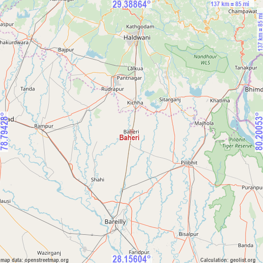
Baheri GPS coordinates[2]
28° 46' 26.976" North, 79° 29' 50.64" East
| Map corner | latitude | longitude |
|---|---|---|
| Upper-left | 29.38864°, | 78.79428° |
| Center: | 28.77416°, | 79.4974° |
| Lower-right: | 28.15604°, | 80.20053° |
| Map W x H: | 137.1×137.1 km | = 85.2×85.2mi |
| max Lat: | 34.9274° ⇑11.9% North |
| Baheri: | 28.77416° |
| min Lat: | ⇓88.1% South 8.09008° |
| min Long | Baheri | max Long |
| 68.82655° | 79.4974° | 96.81° |
| W 63.8%⇐ | ⇒36.2% E |
Elevation
Elevation of Baheri is 194 m = 636 ft, and this is 101.6 m = 333 ft below average elevation for this country.
| Max E: |
3681 m = 12077 ft | 51.4% |
| Avg. | 295.6 m = 970 ft | |
| Baheri | 194 m = 636 ft | |
Min E: |
1 m = 3 ft | 48.6% |
See also: Baheri elevation on elevation.city.
Geographical zone
Baheri is located in North temperate zone (between Tropic of Cancer and the Arctic Circle). Distance of this Northern Tropic circle is 593.5 km =368.8 mi to South.| Distance of | km | miles | from Baheri |
|---|---|---|---|
| North Pole | 6807.7 | 4230.1 | to North |
| Arctic Circle | 4201.8 | 2610.9 | to North |
| Tropic Cancer | 593.5 | 368.8 | to South |
| Equator | 3199.4 | 1988 | to South |


Nearby cities:
15 places around Baheri: (largest is in red/bold)
• Bīlāspur
25.4 km =15.8 mi,  299°
299°
• Deoraniān
16.2 km =10.1 mi,  187°
187°
• Fatehganj West
39 km =24.2 mi,  208°
208°
• Jahānābād
26.8 km =16.7 mi,  126°
126°
• Kemrī
28.7 km =17.8 mi,  277°
277°
• Kichha
15.4 km =9.6 mi,  8°
8°
• Milak
36.8 km =22.9 mi,  240°
240°
• Mīrganj
38.4 km =23.9 mi,  227°
227°
• Nawābganj
29.2 km =18.1 mi,  152°
152°
• Pīlibhīt
33.9 km =21.1 mi,  117°
117°
• Richha
9.2 km =5.7 mi,  164°
164°
• Shergarh
18.6 km =11.6 mi,  222°
222°
• Shāhi
30.5 km =19 mi, 215°
• Shīshgarh
18.5 km =11.5 mi,  254°
254°
• Sitārganj
26.5 km =16.5 mi,  49°
49°
Sources, notices
• [Note1] Compared only with cities in India existing in our database
• [Src1] Map data: © OpenStreetMap contributors (CC-BY-SA)
• [Src2] Other city data from geonames.org with taken over terms of usage.
• [Src3] Geographical zone / Annual Mean Temperature by Robert A. Rohde @ Wikipedia
