Kemrī geodata
Kemrī (Uttar Pradesh) is a populated place; located in India in Asia/Kolkata (GMT+5.5) time zone. With population of 26,726 people, there are 1595 cities with bigger population in this country. Compared to other cities in India, 88.3% of cities are located further ↓South; 61.1% of cities are located further ←West and 52.4% of cities have higher elevation than Kemrī. Note1


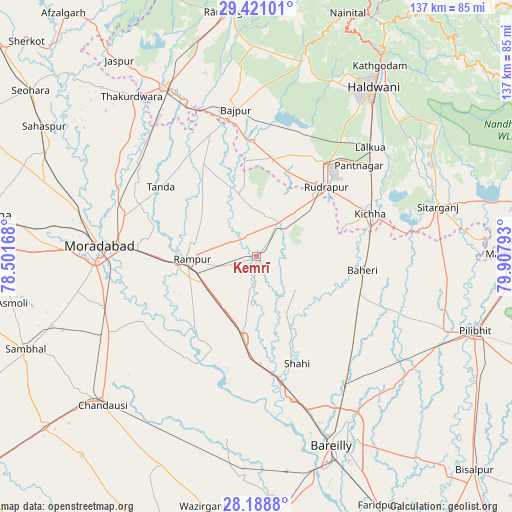
Kemrī GPS coordinates[2]
28° 48' 24.228" North, 79° 12' 17.28" East
| Map corner | latitude | longitude |
|---|---|---|
| Upper-left | 29.42101°, | 78.50168° |
| Center: | 28.80673°, | 79.2048° |
| Lower-right: | 28.1888°, | 79.90793° |
| Map W x H: | 137×137 km | = 85.1×85.1mi |
| max Lat: | 34.9274° ⇑11.7% North |
| Kemrī: | 28.80673° |
| min Lat: | ⇓88.3% South 8.09008° |
| min Long | Kemrī | max Long |
| 68.82655° | 79.2048° | 96.81° |
| W 61.1%⇐ | ⇒38.9% E |
Elevation
Elevation of Kemrī is 188 m = 617 ft, and this is 107.6 m = 353 ft below average elevation for this country.
| Max E: |
3681 m = 12077 ft | 52.4% |
| Avg. | 295.6 m = 970 ft | |
| Kemrī | 188 m = 617 ft | |
Min E: |
1 m = 3 ft | 47.6% |
See also: India elevation on elevation.city.
Geographical zone
Kemrī is located in North temperate zone (between Tropic of Cancer and the Arctic Circle). Distance of this Northern Tropic circle is 597.1 km =371 mi to South.| Distance of | km | miles | from Kemrī |
|---|---|---|---|
| North Pole | 6804.1 | 4227.9 | to North |
| Arctic Circle | 4198.2 | 2608.6 | to North |
| Tropic Cancer | 597.1 | 371 | to South |
| Equator | 3203 | 1990.3 | to South |


Nearby cities:
15 places around Kemrī: (largest is in red/bold)
• Baheri
28.7 km =17.8 mi,  97°
97°
• Bīlāspur
10.9 km =6.8 mi,  35°
35°
• Deoraniān
33 km =20.5 mi,  126°
126°
• Kichha
32.8 km =20.4 mi,  69°
69°
• Milak
22.1 km =13.7 mi,  188°
188°
• Mīrganj
29.6 km =18.4 mi,  179°
179°
• Richha
33.4 km =20.8 mi,  111°
111°
• Rāmpur
17.3 km =10.7 mi,  271°
271°
• Sarauli
36.5 km =22.7 mi,  197°
197°
• Shergarh
23.5 km =14.6 mi,  137°
137°
• Shāhi
30.6 km =19 mi,  158°
158°
• Shāhābād
32.8 km =20.4 mi,  215°
215°
• Shīshgarh
13.7 km =8.5 mi, 128°
• Suār
28.6 km =17.8 mi,  329°
329°
• Tānda
31.8 km =19.8 mi,  306°
306°
Sources, notices
• [Note1] Compared only with cities in India existing in our database
• [Src1] Map data: © OpenStreetMap contributors (CC-BY-SA)
• [Src2] Other city data from geonames.org with taken over terms of usage.
• [Src3] Geographical zone / Annual Mean Temperature by Robert A. Rohde @ Wikipedia
