Shīshgarh geodata
Shīshgarh (Uttar Pradesh) is a populated place; located in India in Asia/Kolkata (GMT+5.5) time zone. With population of 23,471 people, there are 1804 cities with bigger population in this country. Compared to other cities in India, 88% of cities are located further ↓South; 61.9% of cities are located further ←West and 52.8% of cities have higher elevation than Shīshgarh. Note1


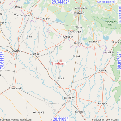
Shīshgarh GPS coordinates[2]
28° 43' 45.408" North, 79° 18' 52.884" East
| Map corner | latitude | longitude |
|---|---|---|
| Upper-left | 29.34402°, | 78.61157° |
| Center: | 28.72928°, | 79.31469° |
| Lower-right: | 28.1109°, | 80.01782° |
| Map W x H: | 137.1×137.1 km | = 85.2×85.2mi |
| max Lat: | 34.9274° ⇑12% North |
| Shīshgarh: | 28.72928° |
| min Lat: | ⇓88% South 8.09008° |
| min Long | Shīshgarh | max Long |
| 68.82655° | 79.31469° | 96.81° |
| W 61.9%⇐ | ⇒38.1% E |
Elevation
Elevation of Shīshgarh is 185 m = 607 ft, and this is 110.6 m = 363 ft below average elevation for this country.
| Max E: |
3681 m = 12077 ft | 52.8% |
| Avg. | 295.6 m = 970 ft | |
| Shīshgarh | 185 m = 607 ft | |
Min E: |
1 m = 3 ft | 47.2% |
See also: India elevation on elevation.city.
Geographical zone
Shīshgarh is located in North temperate zone (between Tropic of Cancer and the Arctic Circle). Distance of this Northern Tropic circle is 588.5 km =365.7 mi to South.| Distance of | km | miles | from Shīshgarh |
|---|---|---|---|
| North Pole | 6812.7 | 4233.2 | to North |
| Arctic Circle | 4206.8 | 2614 | to North |
| Tropic Cancer | 588.5 | 365.7 | to South |
| Equator | 3194.4 | 1984.9 | to South |


Nearby cities:
15 places around Shīshgarh: (largest is in red/bold)
• Baheri
18.5 km =11.5 mi,  74°
74°
• Bīlāspur
18 km =11.2 mi,  346°
346°
• Deoraniān
19.3 km =12 mi,  125°
125°
• Fatehganj West
29.3 km =18.2 mi,  181°
181°
• Kemrī
13.7 km =8.5 mi,  308°
308°
• Kichha
28.5 km =17.7 mi,  44°
44°
• Milak
19.3 km =12 mi,  226°
226°
• Mīrganj
23.5 km =14.6 mi,  206°
206°
• Nawābganj
37.6 km =23.4 mi,  123°
123°
• Richha
20.7 km =12.9 mi,  100°
100°
• Rāmpur
29.4 km =18.3 mi,  287°
287°
• Sarauli
34 km =21.1 mi,  219°
219°
• Shergarh
10.1 km =6.3 mi,  148°
148°
• Shāhi
19.9 km =12.4 mi, 179°
• Shāhābād
34.8 km =21.6 mi,  238°
238°
Sources, notices
• [Note1] Compared only with cities in India existing in our database
• [Src1] Map data: © OpenStreetMap contributors (CC-BY-SA)
• [Src2] Other city data from geonames.org with taken over terms of usage.
• [Src3] Geographical zone / Annual Mean Temperature by Robert A. Rohde @ Wikipedia
